

The town of Oak Bluffs is proud to be “StormSmart.”
Or rather, the town is on its way to gaining said smartness. Being StormSmart has to do with one of those scary, invisible truths that no one wants to think about: sea level rise. And the debate is over. No matter how well the human race conserves energy from here on in, the sea around us will rise. Conservative estimates show the sea rising at least three feet over the course of this century, not including the impact of the planet’s rapidly melting glaciers.
The rising sea will spread inland accompanied by more intense flooding and stronger, more damaging storms. How much this will affect our lives and our shoreline-based economy depends on how well we prepare for it. Rhode Island and Maine already are planning for the three-foot rise.
Oak Bluffs is one of several pilot communities chosen by Massachusetts Coastal Zone Management (CZM) to take part in the StormSmart Coasts Program. The town will have access to state planning tools and technical expertise to help prepare for the inevitable impacts of sea level rise and climate change.
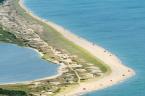
Why Oak Bluffs? Not only is the town located on an Island — it is a peninsula, bounded by water on three sides and ringed with eight coastal ponds. Forty-three houses rest smack on the sand, twenty-two of them on shifting barrier beaches.
The shoreline is varied, with beaches, banks and bluffs, built and unbuilt barrier beaches, and worn out in-town seawalls. Half the town is northeast facing. Higher seas and bigger storms will erode the beaches and banks, pummel seaside houses, and expose roads, more homes, businesses, historic sites and possibly underground sewer and water lines to the sea.
Today the Oak Bluffs flood zone includes low-lying main roads (Beach Road, East Chop Drive, Sea View avenue), the South Circuit avenue and Farm Pond neighborhood, the inner shoreline of Sengekontacket Pond, and the entire Sunset Lake wetlands area. Sea level rise will expand the flood zone.
Through the Storm Smart Coasts Program Oak Bluffs and CZM will identify and map storm and flood zone hazards to assess shoreline vulnerability and then develop a strong, current, scientifically-based coastal flood zone protection bylaw.
When it comes to sea level rise, said a speaker at a recent climate change workshop, “zoning is where the rubber hits the road.” Under CZM’s No Adverse Impact, policy, for example, projects in flood zones must be designed so they do not pose a threat to public safety, increase storm damage to other properties, or strain the town budget for emergency services or disaster recovery efforts.
The voters of Oak Bluffs have been forward-thinking and generous in approving funds for coastal engineering to assess the stability of the Sea View avenue and East Chop bluff coasts. This work, spearheaded by the conservation commission, is in progress. It helped convince CZM that the town is serious enough about protecting the coast to become a StormSmart pilot community. It also puts the town at an advantage when applying for state and federal coastal protection funds.
With so little information out there to help coastal towns, the CZM StormSmart Coasts Program is a godsend, and thanks to the diversity of the Oak Bluffs shoreline the strategies developed through StormSmart will be adaptable to the Island as a whole. The StormSmart Website is packed with valuable information: it is online at mass.gov/czm/stormsmart.
The bottom line is that the environment — and on summer resort islands this by and large means the coast — is the community’s most important asset.
Liz Durkee is conservation agent for the Town of Oak Bluffs


Comments
Comment policy »