
The final version of a statewide Ocean Management Plan takes a step back from plans for sand mining off Martha’s Vineyard after hearing concerns from Vineyard residents and others about dredging offshore sediment. The final plan also expands protected areas for sea ducks thanks to information from Vineyard birders.
A draft version of the plan was released in September, and Islanders took sides on the issue of sand mining, with some saying it would help restore and protect eroding beaches.
Others vehemently opposed mining because of concerns that it would harm creatures living and feeding on the sea floor.

The plan mapped a handful of possible dredging locations, including a large area off the north shore of the Island. But the final document, released early this month, steers clear of those specifics.
Instead, it calls for the formation of a task force which will take a step back and review the criteria for publicly beneficial projects, and put forth recommendations on how such projects would proceed. The task force will have Vineyard representation.
“I think, wisely, they listened to all the people, including the people from here, who were very thoughtful and very proactive in making those concerns known,” said Martha’s Vineyard Commission coastal planner Jo-Ann Taylor.
Ms. Taylor is one of 17 members of the Ocean Advisory Commission, which played a role in shaping the scope of the update.
While sand mining is not currently prohibited in Massachusetts, proposed projects would likely have to clear many permitting hurdles.
The draft version of the plan offered a possible fast track for projects deemed to present a public benefit, as in the restoration of public beaches, but the mention of those pilot projects has also disappeared from the document.
“This is a really important issue, we want to make sure we get it right,” said Bruce Carlisle, executive director of Coastal Zone Management, the state agency that authored the plan.
“We heard from folks opposed [to sand mining] on the Vineyard, but we also heard from communities who strongly support it who have pressing needs for dune and beach restoration,” he said. “We need to advance the conversation some more.”
Sand mining is just one of dozens of sea-based activities addressed in the 300-page ocean plan, which is split into two volumes and available online.
First produced in 2009, it is a wide-ranging set of plans, maps and regulations for state waters off the coast of Massachusetts.
In the first official update of the plan, the state has added scientific information and further developed guidelines for use of state waters.
“The principle here is that plans really should not be static, there are changing conditions in the ocean, and a changing pattern of uses...so plans do need to stay current,” Mr. Carlisle said.
Going forward, state agencies will refer to the document when reviewing permits for offshore projects.
For example, officials at the Martha’s Vineyard Commission consulted the ocean plan when reviewing a 2013 project to install a 4.5-mile undersea cable between Falmouth and Vineyard Haven. The plan told the commission and the utility how to avoid eel grass habitat and other sensitive areas.
“When the proponents went to look at where they were going to lay their cable, they had a good idea of where to lay their cable,” Ms. Taylor said. “It greases up the process for everybody.”
The ocean plan affirms the regulatory powers of the Martha’s Vineyard Commission, the regional planning agency for Dukes County. In a section on wind farm development, it says the commission can decide which wind generation projects are appropriate, referencing a 2012 commission document that mapped where wind projects should and shouldn’t be sited.
In light of this new planning work, the state now “acknowledges that commercial scale wind energy projects are not suitable for the Martha’s Vineyard Wind Energy Area or the Gosnold Wind Energy Area,” the ocean plan reads in part.
This is a change from the previous version, which designated those two areas as the only sites where commercial wind generation could be proposed.
Another proactive measure is the mapping of four routes for the cables that will transmit wind energy.
These sites take sea floor conditions into consideration and avoid critical habitats, Mr. Carlisle said.
One of the 500-meter wide corridors transects Vineyard Sound.
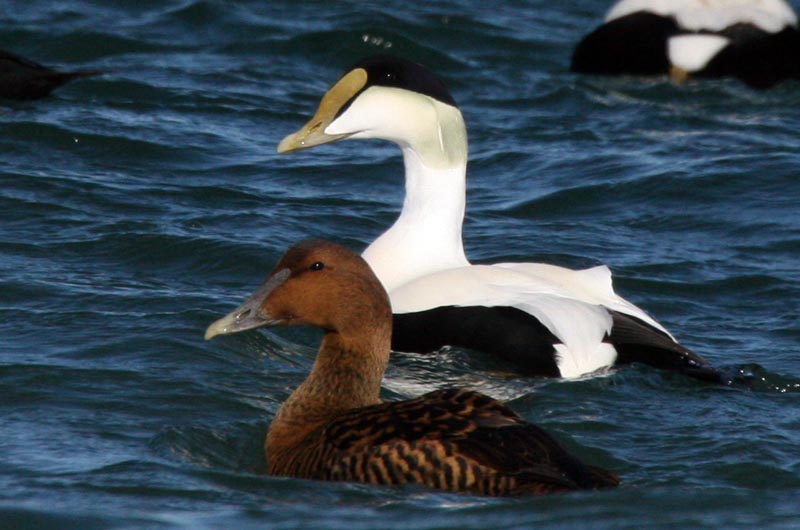
In another change with local implications, the new plan broadens an existing protection area for sea ducks to include more species.
Vineyard birders were instrumental in putting this expansion on the books, Ms. Taylor said.
Thanks to the information the birders provided, the maps now include critical habitat areas for white-winged scoter, black scoter, surf scoter and common eider, in addition to widening the protection area for the long-tailed duck.
“We have some really good information now really showing that the area around the Island in parts of the Vineyard Sound, and in the Nantucket Shoals, are really important for a series of five sea ducks,” Mr. Carlisle said.
Ms. Taylor said Vineyard voices were heard loud and clear during the public comment period, which led to some of the changes in the final document.
“I think our concerns were really well represented,” she said.


Comments
Comment policy »