
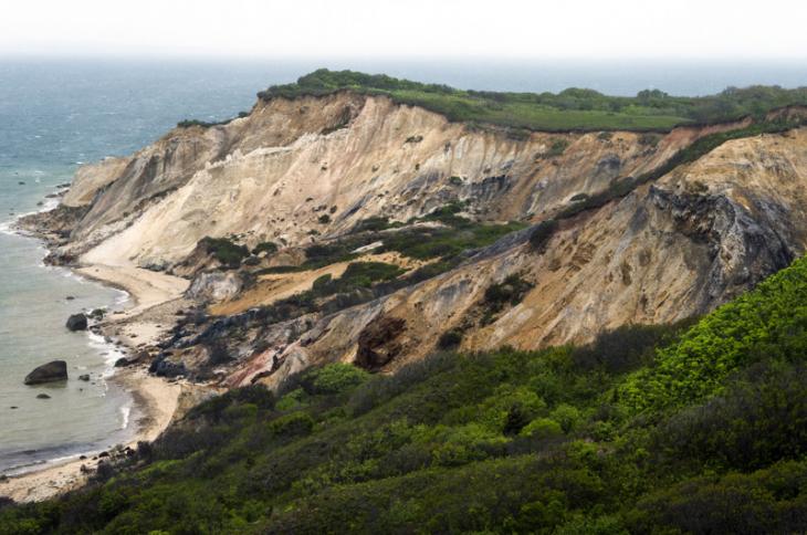
While the Gay Head Light was being moved to safety last week, geologist Byron Stone was at the site working on a project of his own. A major excavation surrounding the lighthouse has revealed never before seen geologic layers that Mr. Stone, a researcher for the United States Geological Survey, hopes will shed light on how and when the Gay Head landscape was created. “Nobody knew that this was here,” Mr. Stone said last Thursday, as bulldozers rumbled around the site and workers prepared to move the lighthouse away from the eroding clay cliffs. Mr. Stone stood beside a large wall of soil, clay and rocks that extended the length of the excavation.
“When I saw the cut, I couldn’t believe it,” he said. “These beds here are just spectacular.”

At the eastern end of the site, at the bottom of the exposure, about 15 feet of ancient white sand underlies several more feet of brown sand that Mr. Stone said indicates a former pond or lake. Both of those layers tilt about 80 degrees to the north, likely as a result of melting ice. Above the tilting layers, a relatively flat layer of cobble from an ancient riverbed supports yet another layer of brown sand from a later body of water. At the top of the exposure, about three feet of glacial till, peppered with rocks and boulders, is covered by a few inches of topsoil.
Mr. Stone’s attention focused mostly on the layer of till near the surface, which he says could help peg the date for when the last continental ice sheet retreated.
“We know now, from the excavation, that the till with boulders is at the top of the pile, and that’s proof for sure that the last ice sheet went over that pile,” Mr. Stone said. He added that boulders found within the glacial layer are just like the ones in the ocean to the east, which are known to have been left by the last ice sheet. The glacier is thought to have extended just south of Noman’s Land and Block Island.
It was no surprise that a layer of glacial till existed east of the cliffs, Mr. Stone said. But its discovery is further proof that the latest chapter in the history of the cliffs was written by the last continental ice sheet, also known as the Wisconsinan glacier.
A car-sized boulder, smoothed by ice and wind, was excavated from the Gay Head site this spring, and will be incorporated into the landscape surrounding the relocated lighthouse. Similar boulders around the Island have been dated to around 24,000 years. But that date isn’t settled, Mr. Stone said. A previous estimate of 18,000 years is still commonly cited in published materials.
“I always thought it was much older,” Mr. Stone said of the last ice sheet. “But I couldn’t convince anyone. Now today we have the evidence that should convince everyone.”
About two years ago, when the town of Aquinnah began planning for the lighthouse project, Mr. Stone consulted both the town and the Wampanoag Tribe of Gay Head (Aquinnah) in finding the most suitable location. Core samples revealed a stable vein of clay extending eastward from the cliffs, about 40 feet below the surface. Mr. Stone believed the new location, about 175 feet from the edge, would be safe from erosion for at least 150 years.
When the lighthouse move began ahead of schedule last week, Mr. Stone rushed back to the Island to collect samples and photograph the layers before they were covered over. He plans to date the white sand this year using a technique called optically stimulated luminescence, which could provide accuracy to within a few hundred years.
In studying changes in climate over long periods of time, he said, “We put a golden spike when the glacier was there.” He added, “If you put the golden spike on Martha’s Vineyard at 24,000 [years], now you are talking about a much longer time over which climate changed. That’s a big deal.”

As many as four glaciers came through from the north, he said, shaping the land that would eventually become the Cape and Islands. During the last advance, sea levels were about 130 meters lower, and all of George’s Bank, extending east from Cape Cod, was a peninsula. Coastal plain sediments extended another 20 or 30 miles from where they are today. Vineyard Sound was still a river valley.
“It was a totally different landscape,” Mr. Stone said. “The last two ice sheets came and pushed materials up on top of the coastal plain. They were brought up some hundreds of feet.”
Mr. Stone believes the highlands along the northwestern part of the Island, between Gay Head and Lambert’s Cove, formed about 140,000 years ago during the Illinoian glacial stage. But not everyone agrees. Robert Oldale, a retired USGS geologist and the author of Cape Cod, Martha’s Vineyard and Nantucket: The Geologic Story, believes that only one glacier, namely the Wisconsinan, shaped the Vineyard as we know it today.
“There are no surface glacial deposits on Martha’s Vineyard that are older than the Wisconsinan glaciation,” he told the Gazette on Tuesday. “But there are older deposits and older glacial deposits at depth.” He added that with the exception of the Gay Head cliffs, the deeper deposits on the Vineyard are seldom exposed at the surface.
The newly exposed layers near the lighthouse have little to do with the Illinoian glaciers, said Mr. Stone, “except that they sit on top of the moraine, which I assume is Illinoian.” As a rule of thumb in geology, younger materials are always deposited on top of older materials.
As Mr. Stone explains it, the last two glaciers slowly plowed through the coastal plain, causing older layers to lift, tilt and fold. The layers at the Gay Head cliffs, which include mostly white sand, black lignite, and red and white clay, tilted to the north, with some layers standing almost on end. For generations, scientists have pored over the cliffs, not only for their stunning deformation, but because they contain a wide range of fossils, from whales, rhinoceroses, mastodons and other animals.
No fossils have been found in the new exposure, most likely because the environment remained uninhabitable long after the last ice sheet retreated. Humans are thought to have arrived in the area about 10,000 years ago.
Mr. Stone’s ongoing work at Gay Head is part of a USGS project to create a statewide map. The stratigraphy of the Gay Head moraine will be added to the map, which is expected to be completed in the next three years. But if Mr. Stone is able to date the white sand sooner, he hopes to write a paper detailing the discovery. “But I need that date to convince people,” he said.
He doubted that core samples or ground-penetrating radar would have revealed the same level of detail as the exposure. But now that the layers have been seen and documented, he believed that core samples could confirm similar formations in the area.
“It’s been very revealing,” he said of the discovery. “And I would expect to find similar things in similar positions.”


Comments (5)
Comments
Comment policy »