
On a mild afternoon this week, a few eiders bobbed up and down in the surf at Squibnocket Beach, occasionally ducking below large waves rolling onto shore. Farther up the beach, a lone buzzard swept over the cobbles where a seal had washed up a few days earlier.
Cars came and went as people took pictures or greeted each other in the town parking lot, which now juts out beyond the eroding shoreline on either side. High tide lapped at the stone revetment containing the lot and a narrow road to the homes at Squibnocket Farm.

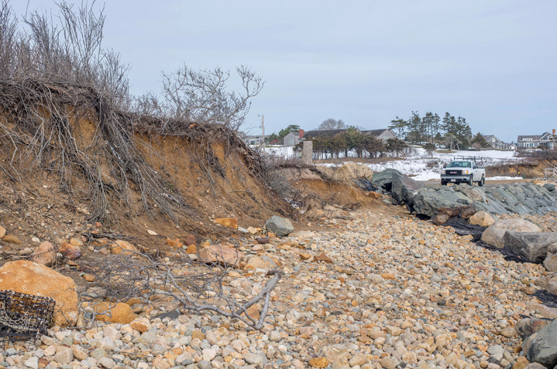
Bert Fischer remembers parties on the beach as a teenager in the 1960s, when the beach was perhaps 50 feet wider. Wearing a gray sweatshirt that matched the sky, he pointed to a large boulder surrounded by the swirling surf that he said used to sit on dry land.
Just seaward of the stone revetment, an old wooden spile poking up from the surf was the last vestige of earlier efforts to slow the advancing sea.
Now the town of Chilmark is working with homeowners at Squibnocket to restore one of the Island’s most unique natural areas. Plans to relocate the town parking lot farther inland and build a raised causeway to Squibnocket Point are in the permitting process. A central feature of the project is removal of the revetment along the parking lot, which in the short term could increase periodic breaches of Squibnocket Pond and alter the pond ecosystem.
Concern for Squibnocket increased after Hurricane Bob in 1991, when a storm surge temporarily broke through the barrier beach to the pond. Hurricane Sandy in 2012 further damaged the beachfront, spurring the town and homeowners into action.
Erosion endlessly shapes the Vineyard, with the effects varying from place to place. With its rocky and well-protected shoreline, Squibnocket has resisted erosion more than anywhere else on the south shore, but some changes have still been dramatic.
Like other up-Island areas, Squibnocket Beach bears the clear signature of the glacial processes that created the Island some 20,000 years ago. The last two glaciers that came down from the northwest stopped within miles of each other, leaving behind boulders and rocks that now form the western part of the Island. Another glacier from the northeast is thought to have deposited the finer material that makes up the eastern part of the Island.

The sandy south shore is now eroding at about six feet per year, much faster than parts of Squibnocket, with its point jutting out slightly to the south, creating a subtle embayment and providing shelter from the prevailing southwest winds and the scouring of waves.
Thousands of years ago, the barrier beach system that makes up Squibnocket may have extended to Noman’s Land, about three miles to the south.
Duncan Caldwell, a prehistorian and Aquinnah resident, has observed ancient tree stumps uncovered at Squibnocket that he believes may indicate former swamps or ponds.
The tree roots were anchored in freshwater peat, Mr. Caldwell said, as might be the case at the edge of a pond. “There are actually even artifacts in among these things. They were part of a stable environment where people lived,” he said. At the same time, large mats of saltwater peat sometimes wash up, indicated the presence of a former lagoon where barrier beaches may have fanned out from Noman’s, as they do now from the point.
Mr. Caldwell last observed the stumps in 2014, before they were covered up by at least five feet of sand, which posed something of a mystery. “There was no storm during those three weeks,” he said. “It was really a fairly calm period and yet there was this dramatic change.” He said even coastal geologists were somewhat baffled by the event, underlining the complexity of coastal processes.
Squibnocket harbors a rich natural and cultural history. A large number of Native American burials have been recorded near Round Pond, north of the point. “I think in the latest scrape there were approximately 350 identifiable features,” Mr. Caldwell said of a recent study by the Public Archaeology Lab of Pawtucket, R.I. “It’s very clear that the area had enormous cultural significance . . . . an area that deserves probably very special protection.”

Round Pond is a hidden treasure, invisible from public land and the sea, and well-protected from erosion. “Even though it’s filled in and eutrophied, it’s been a major feature on the Island for a long time,” Mr. Caldwell said. West Tisbury resident Mal Jones reportedly took a core sample of the pond bottom years ago and counted more than 7,000 stratigraphic layers, each one representing a year.
A cove near the town lot has also filled in over the years, and its resident fish and eel populations have declined. “People would be lying along the back here catching perch. You don’t see that today,” Mr. Fischer said, looking out over the small cove where granite cobbles have washed over from the beach. A tall stand of phragmites has also taken root, another change from past years.
But as long as anyone can remember, fishermen in the warmer months have made the trek to Squibnocket Beach to cast for striped bass from shore. “Historically it was one of the great fishing areas on the East Coast,” said Kib Bramhall, a West Tisbury resident who has fished there for 65 years and recalls some of the changes caused by erosion.
A glacial outcropping just north of Squibnocket Point known as the mussel bar is a popular haunt for stripers. The Squibnocket Striped Bass Club set up on the point in the 1800s, along with the New Providence Club. “Between the two they erected a number of fishing stands or piers all around the point,” Mr. Bramhall said. All that remain today are some metal spikes where there was once a fishing pier.
“In recent times Squibnocket has continued to be a very good striped bass fishing place,” Mr. Bramhall continued “But it has never regained the efficacy that it had before Hurricane Bob in 1991. That destroyed most of the mussel beds off Squibnocket Point and the fishing has really never gotten back to what it was.”
The mussel beds have done more than attract stripers. As a large, rugged structure, they have further armored the coastline.
“Of all the places along the entire south shore of the Vineyard, the mussel bed is one of the areas that has been most resistant to erosion,” said Mr. Caldwell, who has advocated for similar manmade structures to help slow erosion at the beach. He said living reefs can potentially adapt to sea level rise by growing toward the light.

Erosion rates vary around the Island. At the Squibnocket parking lot the rate is around 1.5 feet per year, according to the state office of Coastal Zone Management.
But erosion is not a linear process.
“Storm impacts and other short term, high intensity events make it difficult, if not impossible to predict erosion on a short time frame,” wrote Greg Berman, a geologist with the Woods Hole Sea Grant program and the Woods Hole Oceanographic Institution, in a 2014 study for the town. In some places a large storm could erode 10 or more feet in a single day.
One thing that is clear is that the rates are increasing.
Recession at Squibnocket averaged 1.3 feet between 1897 and 2011, but 2.3 feet since 1955. And rising sea levels have increased over the last hundred years as a result of climate change. But even if the sea did not rise, Mr. Caldwell calculates that an area just east of Squibnocket has been eroding at about 5.6 feet per year, and that the faster zone of erosion is slowly creeping westward.

At current rates, the shoreline would reach the Squibnocket Pond in about 50 years, according to Mr. Caldwesll’s calculations. That would likely result in the pond’s first long-term breaching since the early 1900s.
Already pond water naturally seeps through the two barrier beaches to the east and west, and a herring run opens to Menemsha Pond to the north, which in turn opens to the sea. Historically natural inlets have formed. But a permanent breach could greatly alter the pond habitat.
“If they pull out the revetments it’s going to be more natural but it’s highly likely that those ephemeral inlets will form every now and then,” Mr. Berman told the Gazette by phone this week. “If that happens or there gets to be more salt water, that can change the biota within the pond itself.”
Meanwhile, as study and planning continue at Squibnocket, Mr. Caldwell prefers to take a larger view, advocating for electric cars and alternative energy sources to reduce greenhouse gas emissions and the resulting sea level rise.
“If we don’t stop global warming, issues like access to Squibnocket Point for a few people are going to be very minor indeed,” he said.


Comments (3)
Comments
Comment policy »