
Imagine an ocean of islands spanning ten million square miles. Now imagine you must navigate that world without charts or instruments — without even a compass — to find a tiny island 2500 miles away. If you fail, you will die. Impossible you say? Not at all. Such voyages were accomplished time and again a thousand years ago in the Pacific by ancient Polynesian seafarers. How they accomplished this feat has been a puzzle since Captain Cook first revealed their watery domain in the late 1700s.
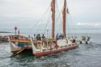
In 1974, a young Hawaiian man, Nainoa Thompson, began his quest to understand his ancestors’ ancient navigational art by apprenticing to Mau Piailug, one of a handful of traditional navigators from the island of Satawal in Micronesia. He also spent hundreds of hours studying the sky in nature and in a planetarium at Hawaii’s Bishop Museum. Then he navigated Hokule’a, a replica of a Polynesian double hull voyaging canoe, on voyages spanning four decades and 140,000 nautical miles.
On June 28, Hokule’a will visit Martha’s Vineyard on its a voyage around the world, navigating the way the Polynesian explorers once did — without instruments or charts and by relying instead on signs in the stars, waves and flight of birds. The voyage is a call to attention about the pressing need to live sustainably within our planetary budget of natural resources.
The modern instrument navigator inhabits a world of abstractions. To find his place in the world, he reduces a star’s altitude to a number, then consults his astronomical tables, does some math and plots his position on a chart. He then forgets his navigational tasks until it’s time for another peek through his sextant.
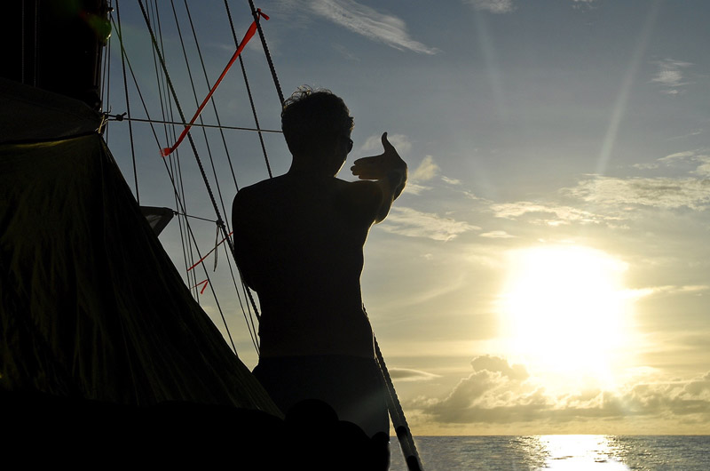
But the non-instrument navigator can never really rest. Nainoa constantly senses the direction of his vessel; in the soles of his feet, in the feel of wind on his cheek, in the sound of the rushing wake. He is continually, as he describes it, “in the navigation.”
Nainoa’s system of navigation is, like all great discoveries, simple enough to describe yet extremely complex to practice. As a compass, he uses the rising and setting points of stars. Antares, for example, rises in the southeast and sets in the southwest, Altair rises east and sets west, and Vega rises northeast and sets northwest. Polaris twinkles almost due north and two stars in the Southern Cross, Gacrux and Acrux, point south. The stars we can see change as earth circles the sun and as we move north or south upon the globe, so there are many risings and settings to memorize. In the entire menu of Nainoa’s directional stars there are many hundreds.
Swells also provide clues to steer by. In the Pacific, steady trade winds from the northeast or the southeast stir the ocean into a steady beat of swells that can be easily observed. It is much more difficult to read the smaller wave trains set in motion by evanescent storms and to find any coherency at all in the patterns when a gale overtakes your vessel.
The big trick, of course, is not just knowing where you are going but where you are at any given moment. Determining latitude, our position north and south, is accomplished by judging the altitude of stars above the horizon when they are at the meridian — the highest point in their arc across the sky. Each star tells a different story because it arcs differently, so the navigator has to memorize the paths of hundreds. Judging altitude takes practice and the ability to use one’s hand as a crude instrument. Nainoa’s little finger, when held at arms length and adjusted to lie along the horizon, marks off two degrees of altitude. Sighting along the crease between his hand and upthrust thumb gives a reading of 13 degrees.
During Nainoa’s study in the planetarium, he traveled across the ocean in compressed time to observe other patterns in the wheeling night sky. He noticed certain pairs of stars rising and setting on the horizon simultaneously —but only at one specific latitude — a phenomenon he calls “synchronous rising and synchronous setting.”
When Murzim (near Sirius) and Alhena (in Gemini), for example, drop below the western horizon at the same time he knows the canoe is at six degrees south latitude. When Sirius and Pollux set together he knows that his position is 17 degrees south.
Longitude cannot be found without a chronometer, so the navigators rely on a system called, appropriately enough, “dead reckoning.” They estimate the time and speed they steer a given course and, on a mental map, they place themselves along an imaginary course line toward their destination.
The voyages of Hokule’a — and of other recreated Polynesian canoes — have proven the concept that such vessels could have carried colonists across thousands of ocean miles and that you do not need instruments to find your way across trackless space.
The lesson for those of us confined today within four walls and the concepts of math and science, is an appreciation for another way of seeing the world. Ancient Polynesian navigators blended with nature on their long ocean voyages. Nainoa sleeps only in half-hour catnaps, perhaps four hours each day, constantly alert to his course and speed, the currents, waves and stars. Approaching landfall he scans the sky for birds that fly to sea to fish in the day and return home to their nests at night. A blue underbelly on a cloud is the reflected light from a distant lagoon, and a calming pattern to the sea swells may indicate an interruption to the constant trades caused by a distant island.
“When everything is going right,” Nainoa once explained to me, “I get into a zone, a special place in which all of my relations with the canoe, the natural world and the crew are integrated. You have to be in that special place to navigate well. When you are in the zone, you feel ahead of the game. You find yourself naturally thinking about what will happen next and you are acting in the future, not reacting to things in the past. You have the star patterns in mind and you seem to know where you are even when the sky is cloudy and you can’t see the stars. You begin to anticipate the weather. It’s an awesome feeling but it’s hard to describe. It is like being inside the navigation, participating from the inside.”
To learn more about Hokule’a and her voyage around the world, visit hokulea.com. To learn more about her visit to Martha’s Vineyard you may contact Sam Low at samfilm2@gmail.com. Mr. Low is a former Hokule’a crewmember and the author of Hawaiki Rising – Hokule’a, Nainoa Thompson and the Hawaiian Renaissance. He lives in Oak Bluffs.


Comments (1)
Comments
Comment policy »