2010

bridge

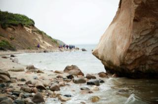
The Chappaquiddick ferryman steered the On Time across the River Styx, previously known as the Edgartown Harbor, last Saturday morning. “Have a memorable walk,” the captain muttered.

Ninety minutes earlier an erstwhile cluster of 36 hikers had gathered at Quammox, not a Harry Potter game but a new Martha’s Vineyard Land Bank property of some 23 acres on Chappaquiddick.

Bill Veno convened the group of hikers promptly at 8 a.m.

2009

great rock

The walk to Great Rock Bight from the nearest parking area takes 15 or 20 minutes. This year, that extra mile or so could have been considered the true beginning of the annual Martha’s Vineyard Land Bank cross-Island hike. Best to have factored it into your plans, if you intended to meet up with the group of hikers before they set off on their 21-mile trek through the early-summer wilds of the Vineyard.

2008

pond

His feet were sore. His toes and heels threatened to blister. They had taken him across ponds, through wetlands and tall grass, under the cover of pines and oaks, over soft moss and hard asphalt, around the bends, down the valleys and up the hills.

2007

Comfortable shoes selected. Sunblock and bug spray applied. Water
packed and muscles stretched.

This was the checklist for the 40 walkers gathered on Jetty Beach in
Oak Bluffs early Saturday morning. Ahead was the Cross-Island Walk, a
hike sponsored by the Martha's Vineyard Land Bank, led every year
to celebrate National Trails Day and to expose people to the
Island's conservation lands and the paths and back roads that
connect them.

Pages