


Mark Lovewell
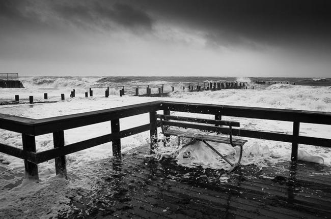
A huge Atlantic Ocean storm with the ferocity of a hurricane and the power of a winter northeaster pounded the Vineyard this week, raging across barrier beaches and sandy Island perimeter with flood tides not seen since the double hurricanes of 1954.
On Wednesday ferry service to the Vineyard was suspended and the Vineyard was lashed by high winds and angry seas, which rose up and flooded the main areas of the down-Island towns with two or three feet of salt water.
Coastal houses became islands and the Beach Road between Edgartown and Oak Bluffs was virtually destroyed. By 6:30 p.m. Gov. William Weld declared a state of emergency for all the coastal counties in Massachusetts.
And when it was all over, the face of the Vineyard was completely changed.
In Gay Head Walter Delaney recorded a 72 m.p.h. wind gust at 1 p.m. Wednesday. In Edgartown Nathan Durawa observed a Tower Hill wind anemometer top 80 m.p.h. at 5 p.m.
Mark Lovewell
While some meteorologists compared the storm to the Blizzard of 1978, many Vineyarders compared it with bigger storms, like Hurricane Edna in 1954.
“There has not been such flooding since 1954 when we had Carol and Edna,” declared Ruth Redding, who lives near Waban Park in Oak Bluffs.
In Vineyard Haven Five Corners was closed to traffic for nearly 20 hours. Lake street in front of the Wesley House in Oak Bluffs was impassable for most of Wednesday from both wave action and tides. In Edgartown, the tide rose up and over Dock street and flooded half of lower Main street.
At the National Weather Service headquarters in Boston, meteorogist Mike Girodo admitted after looking at a satellite map: “This is one of the most unusual storms I have ever seen.”
The storm began in cold waters south of Nova Scotia last week, and by its strength and size is sucked up the winds and power of a minor hurricane off Bermuda called Grace.
Mark Lovewell
This first evidence of the monster storm circulating in the Atlantic was felt by Vineyarders on Monday when high northeast winds began to pound the Island through the day and night. Tree limbs, weakened by the hurricane in August, came down all over the place. On Monday afternoon, ferry service to Chappaquiddick was suspended because the tide was so high.
Small craft advisories were changed to gale warnings on Tuesday. The Vineyard began to hear predictions for what meteorologists would later call the worst ocean storm to hit New England since the Blizzard of 1978. Like the storm in 1978, this storm was backing onto the coast, moving from east to west.
On Tuesday, a Coast Guard buoy marking the outermost part of Edgartown harbor broke from its mooring and was found by David Smith on East Beach on Chappaquiddick. A catboat washed up on Lagoon Pond. The county barrier beach at Norton Point, already weakened by the late summer hurricane, was washed by rising seas from Katama Bay.
On Wednesday morning, there was frantic activity in Vineyard Haven harbor. Philip Hale, president of Martha’s Vineyard Shipyard, looked across the water to the moored topsail schooner Shenandoah rising and falling on the waves and said: “I’ve never seen it so rough.”
The center of the peculiar storm was still over 300 miles from shore. A schooner called Lana and Harley was towed through four-foot seas from outside of the Vineyard Haven harbor breakwater to the inner harbor. School children from Chappaquiddick were given the day off. For two consecutive days, ferry service to the tiny island had been sporadic at best.
Steamship Authority ferry service to the Vineyard was suspended Wednesday morning as the winds and tide increased steadily.
At the height of the storm in seas south of the Vineyard, Coast Guard crews rescued survivors of a sinking vessel on Nomans and a sailboat crew 100 miles south of Nantucket.
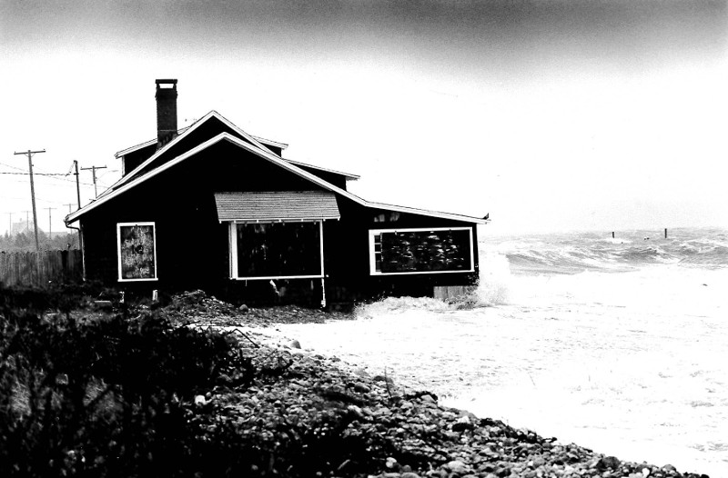
By 2 p.m. Wednesday seas were pounding the outside walls of East Chop summer homes on Highland Drive. Beach Road in front of the Martha’s Vineyard Hospital entrance was flooded and closed. A police barricade marked limits of safe passage. Five Corners was under two feet of water, with still three hours to go before high tide.
Swollen tides turned many areas into small islands, leaving them unreachable by car, including w ole sections of Lagoon Pond and East Chop. Waves smashed aid destroyed the Tisbury Wharf dock on Beach Road in Vineyard Haven. Ralph Packer, who compared the storm to the Blizzard of 1978, said waves rolled over the sea wall and turned Beach Road into a river.
Diesel fuel from an unknown source began to wash in with the seawater. Environmental police officer William L. Searle was called in to investigate; he speculated that the fuel came from the broken Packer dock. Boats blown by the northeast wind began piling up on the beach. One was a 48-foot schooner named Ishmael. It ended up on the beach next to Mr. Packer’s fuel tanks.
All over the Vineyard there were reports of utility poles on fire, with numerous pole fires reported up-Island. Scattered power outages and flickers occurred throughout the day and night.
It was three hours before the seas began to subside from Dutcher Dock at Menemsha. High tide was at 1:30 p.m. Everett Poole of Poole’s Fish Market said the waters rose above Dutcher Dock but remained below the bulkhead for a long time.
Water from Oak Bluffs Harbor poured into Sunset Lake and extended up into Dukes County avenue. At Greenleaf avenue waves lapped on the porch steps of several homes. Two elderly residents of the avenue were evacuated.
Early in the evening, many hours after service was suspended on the Chappy ferry, a cottage near the ferry point on Chappaquiddick was reported on fire. No fire trucks from Edgartown could cross the channel and the lone Chappaquiddick fire truck was unable to reach the fire because the deep salt water on the road extended from the ferry slip all the way to the entrance of Litchfield Road. The house, owned by Peter M. DiBari, burned to the ground. The blaze was visible all across the Edgartown waterfront. A crew of firefighters from the Edgartown side were taken to the scene by town harbor master Robert Gilkes, but with no equipment they could do little but watch.
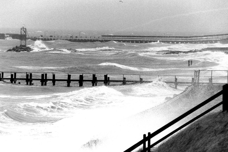
The Edgartown Lighthouse became an island. Dock street in downtown Edgartown was flooded more than anyone had seen since 1954. Four hours before high tide Dock street was under two feet of water. Seas rose some two feet above the main dance floor in the Edgartown Yacht Club, and made their mark on the wall along with great storms of the past. The tide on Wednesday was higher than the mark in 1954, and third only to the 1938 and 1944 hurricane high-water marks.
Wednesday’s storm did more damage than could be inventoried in a day. Erosion estimates at East Beach and Wasque were incomplete, but it is known that the damage was severe. At the height of the-storm virtually all of Wasque Point and most of East Beach were under water, according to David Belcher, superintendent for the Trustees of Reservations. Wind and waves tore over 40 feet of sand from East Beach.
“For us this was a repeat of Hurricane Bob,” said Mr. Belcher. In other ways it was worse. “There were several breaks in our primary dunes that survived Hurricane Bob but did not survive this storm.” He said Poucha Pond and the swan pond at Wasque were so deluged by the Atlantic Ocean that for a time they were one with the sea.
Norton Point was also severely hit, its barrier beach dunes flattened to almost nothing. A boathouse which has reportedly stood on the outer reaches of North Neck near John Oliver’s Point for 100 years was swept away by the tide.
Martha’s Vineyard was without Red Cross shelters, but according to George Gordan, chairman of the local chapter, there was no need. Only a couple of people in Oak Bluffs needed shelter and the Red Cross provided them with a motel room for the night.
Jim Mitchell, the county civil defense director, said: “It was a northeaster. The impact on the public was much less than Bob. There were no major power outages.” The impact of this storm was mostly flooding, he said.
But elsewhere on the Cape, civil defense directors had a much larger role.
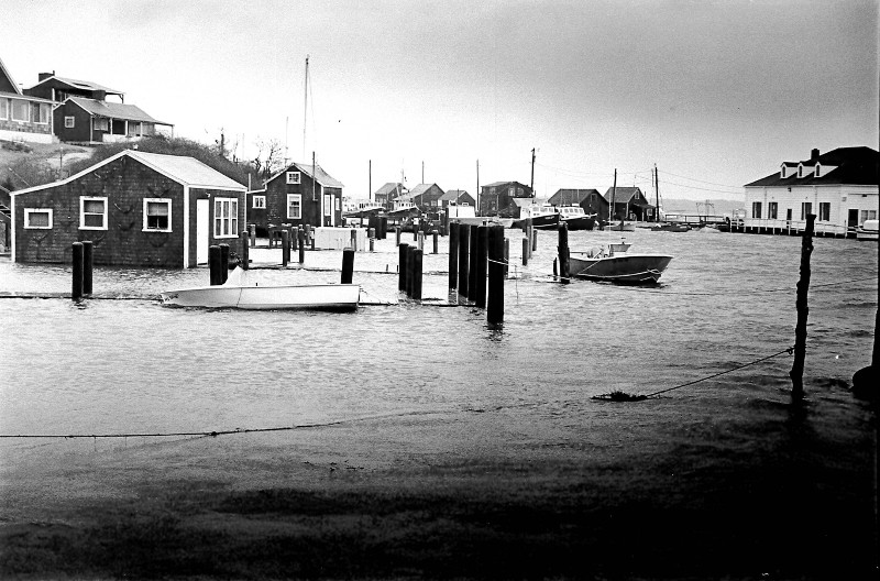
Overnight a 48-year-old historic fishing boat named Joanne and Michael sank in the Oak Bluffs harbor. The sinking created a fuel oil spill which later required the attention of Coast Guard investigators.
State environmental police officer William L. Searle was called in to investigate a report that someone was lost on the Beach Road late Wednesday. He was the only police officer with a four-wheel drive vehicle available on that side of the Island. “It rivaled any amusement ride I’ve ever taken,” he said after the trip. Mr. Searle found the road along the beach covered with sand and rocks, waves crashing all around the vehicle.
“No one was lost,” he said.
The storm will go down in the records as causing the most severe erosion on Island in a long time, said Jo-Ann Taylor, a coastal planner with the Martha’s Vineyard Commission. She said in some respects it will leave a larger mark on the community than Hurricane Bob.
“I think there is a lot more damage. The hurricane may have brought us fierce winds but that was for three hours. This has pounded us for close to five days,” she said.


Comments