


So you’re buying a house on Martha’s Vineyard. Congratulations. Chances are you’ve been here before, so you know the people are pretty easy going, the beaches are great, and there’s lots to do, especially in summer. Just don’t assume you can find your way around. Without laughing. Or crying.
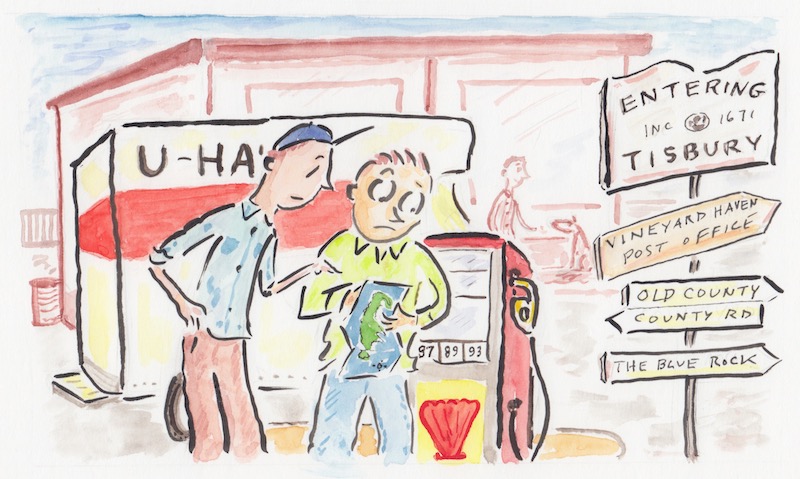
You might meet some new friends from Vineyard Haven. That’s what everybody calls the town between Oak Bluffs and West Tisbury. Good luck finding it on a map. Its real name is Tisbury, but people rarely refer to the town by its real name.
Don’t make the mistake of assuming logic or good order has anything to do with the way we name our towns and streets. If logic prevailed, we would call the next town over West Vineyard Haven. Nobody does that.
You might also be confused about our streets and avenues. Many of them are dirt, and a frighteningly high percentage of them are all but impassible in anything short of a military vehicle, such as an amphibious tank.
If you get invited to dinner in one section of Tisbury, er . . . Vineyard Haven, almost every set of directions will include the blue rock. It’s a rock, oddly enough, painted blue near the end of Lake Street, which goes to Lake Tashmoo, which is really a salt pond, not a lake.
Your friends might say, “Take a left at the blue rock, go through the giant puddle, take the third right, and we’re the fourth house on the right.”
If the paint ever wears off that rock, no one will ever find anything.
We also like to play with little puns when naming our streets here. For instance, if you take a right at the blue rock, and you get lost in the bewildering rabbit’s warren of dirt streets and avenues, you might find yourself on Goah Way. Real place. People live there.
Chances are, you will still be lost a half-hour later, and you might stumble onto Bumpy Road. Which is indeed, bumpy—very bumpy. If you get really, really, lost, you might end up in Oak Bluffs on an old dirt road named . . . Old Dirt Road.
And don’t even get started about County Road and Old County Road. They’re not in the same neighborhood, not even in the same town. They are, however, in the same county.
At least those are real places. If you use an on-line mapping program for driving directions, sooner or later you’re going to be directed into a wooded lot or onto a walking path. These are called paper roads. Maybe there used to be a road there at one time, and they still exist on some ancient map nobody uses, but at present they don’t resemble a road in any way, shape, or form. This is especially disheartening when you are looking for a shortcut to avoid summer traffic tie-ups. It’s right there on Google Maps, clear as day, a way around that maddening back up. But it’s a paper road, and you’re back in traffic.
You may think you could find solace in Edgartown, where the downtown streets appear to be laid out in a logical grid. Driver beware. Most of those streets are one-way, with no rhyme or reason except to confound drivers.
Main Street promptly becomes one way when you get downtown. From there, it is almost impossible to get back out of town. There are people who have lived on the Island for years who are reluctant to come to Edgartown because they are afraid they will never get back home. Your best bet is to determine which way seems logical, then turn the other way. You will find your way out eventually.
Lastly, there is that whole up-Island rural delivery thing.
If you live in West Tisbury, and you want to get your mail delivered to a mailbox at the end of your driveway, you have to go to the Vineyard Haven (Tisbury) branch of the post office because that’s where they dump the mail when it comes off the boat. They will give you a Tisbury address to have your stuff mailed to. It may or may not be based on your actual street address. Probably not. You have to use the Tisbury address to get your mail in West Tisbury. If people use your physical address, you’re likely to never see the mail.
Try explaining that to your credit card company.


Comments