
Recent local events give me hope at a time when climate change news is becoming more and more dire.
Climate change
July 22, 2021
Kate Warner
As a heat dome persists over the American West, an untamable wildfire rages over southern Oregon and record hot temperatures and water shortages make life in the West difficult, floods in much of Europe — Germany, Belgium, The Netherlands, Switzerland, parts of England and now China — have also had a devastating effect.
July 22, 2021

Noah Asimow
Eversource has canceled a long-awaited battery energy storage project planned for Martha’s Vineyard, complicating a plan to achieve ambitious green energy goals on the Vineyard.
August 12, 2021

Brendan O'Neill
The Martha’s Vineyard Commission is taking an important step to address the Island’s growth crisis through a new carrying capacity study.
2007
October 11, 2007
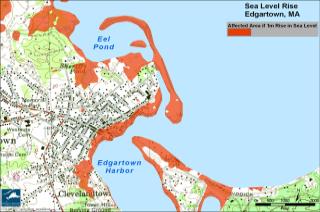
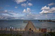
Here is a sobering fact: we live on an Island and the sea is rising.
The consensus among coastal scientists is that our children or grandchildren will see a sea level rise of about one metre in this century, an estimate that does not even take into account the rapid rate of melting glaciers. The New York Times reported last week that “the arctic ice cap melted this summer at a shocking pace, disappearing at a far higher rate than predicted even by the most pessimistic experts in global warming.”
August 6, 2007
Having lived in the Midwest for a few years, Woods Hole Research
Center scientist Dr. Michael T. Coe knows that global warming sounds
good to some ears - it implies shorter winters and higher
temperatures.
April 19, 2007
Geological time mostly runs incredibly slowly, in measures of
hundreds of thousands, if not millions or billions of years. No wonder
Bob Woodruff was excited about what happened over the weekend.
2006
September 28, 2006
Following a category two hurricane or a 50-year coastal storm, Beach Road and Eastville avenue would likely be buried under water, and the only remaining access to the Martha's Vineyard Hospital in Oak Bluffs would be Temahigan Road, according to preliminary results of a risk assessment study prepared by an independent consultant.
But even under a worst-case storm scenario, the actual hospital facility would avoid major flooding, the preliminary study suggests.
2002
January 31, 2002
When the groundhog awakens from his long winter nap tomorrow at
dawn, he will rise from his hole in the ground and think he overslept.
If he lived on the Vineyard, he'd think it was already spring.
Forsythia are in bloom, and in the past week there have been
sightings of honeybees and, in West Tisbury, a butterfly. Snow drops are
in bloom in various places from Edgartown to West Tisbury.
1999
December 31, 1999
The changing shoreline on Martha's Vineyard variously fascinates, startles or horrifies people, depending on where they live or own property. The strongest supporting images of erosion are provided by destruction of buildings located at the water's edge, such as lighthouses and Worlds War II military bunkers. Among the latter, a concrete bunker (part of the Katama Naval Air Station target track) once 180 feet from the shore at South Beach in Edgartown was last seen far offshore, drowned in the surf. The associated rate of shoreline retreat comes to about 12 feet per year.