
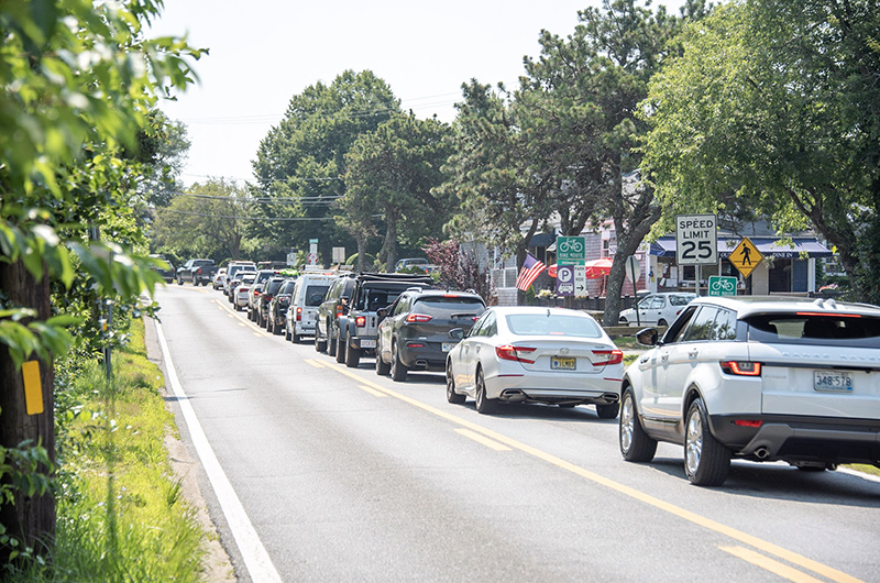
Summer vehicle traffic numbers from the Steamship Authority are on track to match last year’s record-breaking figures, and backups continue to snarl Island roads in July and August. As Islanders seek shortcuts and shun major intersections, data from the latest Martha’s Vineyard Commission Regional Transportation Plan and numbers from the Steamship Authority confirm what drivers already know: summer traffic has become an inescapable fact of Vineyard life.
The number of vehicles annually transported to and from the Vineyard by ferry — and onto the 177 miles of public roadways here — has increased by 16 per cent since 2007, according to numbers from the commission and the Steamship Authority. The number of vehicles registered on the Island, which peaked in 2010 at about 30,000, totaled 25,600 in 2015 — nearly twice the 1990 total.
Last summer, the SSA carried a record number of vehicles to and from the Island for the third year in a row, and so far this summer the ferry line has matched last year’s numbers within a percentage point.
In the first three weeks of July, the boat line carried 36,176 automobiles and 8,508 trucks, SSA communications director Sean Driscoll said, a small uptick of 25 cars and five trucks over the same period in 2018.

This June’s vehicle traffic was down slightly compared to last year: 44,398 automobiles and 13,680 trucks, compared with 44,796 and 13,801 last year.
“In the last few years we’ve hit highs in most of our categories,” Mr. Driscoll said. He declined to speculate about whether the boat line has reached a leveling off point. “It’s natural to see some backing off from that. Whether it’s a plateau or a one-off has yet to be seen,” he said.
Areas of high traffic are well-known: the notorious Triangle intersection in Edgartown; Five Corners in Tisbury, and Sea View avenue in Oak Bluffs during a ferry arrival.
At the Square Rigger in Edgartown this week, a line of cars on each side of the restaurant inched slowly toward the Triangle intersection of Beach Road and Edgartown-Vineyard Haven Road on Tuesday afternoon. Restaurant owner Dana Rezendes said impatient drivers often use his parking lot as a cut-through from one road to the other — to the extent that he hasn’t been able to hang onto the planter marking a handicap space for more than a week at a time.
“It’s gotten hit and run over. We saw somebody with it hooked to their bumper going down Dark Woods [Road],” Mr. Rezendes said. For his part, Mr. Rezendes avoids the Triangle at all costs, even though that means looping back up to the roundabout to get to the Edgartown-West Tisbury Road, lengthening his afternoon commute.

James Hagerty, Edgartown’s town administrator, said he’s gotten calls from frustrated drivers demanding a roundabout at the Triangle, where traffic can back up to Bend in the Road Beach on the Oak Bluffs side and as far out of town as Holly Bear Lane on the Vineyard Haven Road.
An Edgartown roundabout is “not even a twinkle in someone’s eye,” said Mr. Hagerty, who said he’s seen worse traffic in years gone by.
In Tisbury, fire chief John Schilling and EMS coordinator Tracey Jones said their first responders traveling in personal vehicles often struggle to get to calls, as there are sometimes no alternative routes to avoid the hot spots in that town, like the Five Corners intersection and the four way snarl at Edgartown-Vineyard Haven Road and State Road.
“That traffic definitely becomes a problem in that regard,” Mr. Schilling said.
Lieut. Chris Dolby of the Edgartown police said when the Chappaquiddick ferry line reaches Pease’s Point Way, Chappy-bound motorists are told to come back later.
“We’ve had to do that the past couple of days,” Lieutenant Dolby said on Wednesday. “We have to shut it off there, because we simply have no room to stack cars. We tell people to drive around for a little bit.”
Up-Island, traffic from the Saturday morning farmers’ market snakes up the Edgartown-West Tisbury Road every weekend. Other slowdowns clog the road near the airport entrance and the intersection with Barnes Road.

Recently-hired airport director Cindi Martin said a surface transportation study is underway, with a report expected in the early winter.
“We’re not blind to the fact that there is an issue, and we want to make certain it gets addressed,” Ms. Martin said.
Results from the transportation study will allow the airport to develop “a thorough approach to solving a problem, that has room to grow and to flex if need be,” she said.
The issue is hardly a new one; seasonal traffic has vexed Islanders for decades. In 1997, voters in all six towns overwhelmingly passed a nonbinding referendum to limit ferry traffic to no more than what came to the Island in 1995. But the numbers have continued to climb.
“There can be no dispute about the dimensions of the traffic and road system problems facing the Vineyard,” a 1997 Gazette editorial said. “The choking of Island roads will only get worse in the absence of solutions to ease the burden of too many cars, trucks and buses on a rural road system never meant to carry this volume of traffic.”
Sitting in his Oak Bluffs office in 2019, Martha’s Vineyard Commission executive director Adam Turner said the Island is now at a tipping point.
“The Island is nearing a moment where it’s going to have to decide whether it’s going to maintain its rural character or it’s going to begin to shift to a more suburban one like the Cape,” Mr. Turner said.
In some areas, action has been taken to mitigate the problems. In 2013, after prolonged debate, a roundabout was installed at the intersection of Edgartown-Vineyard Haven Road and Barnes Road in Oak Bluffs, and construction is expected to begin within the year on a state project to improve pedestrian and bike lanes on Beach Road. But road improvement projects are often met with anxiety about the loss of the Island’s character for the sake of mitigating traffic for eight weeks of the year.
The commission recently received a grant from the Massachusetts Department of Transportation to install traffic counters at six locations around the Island, which will enable planners to collect consistent data over multiple years.
“We don’t have any traffic lights. We’re not used to large volumes of traffic, nor do we have the infrastructure to really support it,” Mr. Turner said. “We don’t have four-lane roadways. We operate 10 months a year under rural conditions, and two months a year, we have 80,000 more people here.”
But looking to the future, Mr. Turner said traffic is not the largest threat to Island roadways; a changing climate is.
“My other priority is really looking at how we’re going to retrofit all these roadways and other nearshore infrastructure to climate change,” Mr. Turner said. “We have roadways that flood. We have storms that do more and more damage.”
To participate in the Vineyard Gazette's community survey about vehicle traffic on Martha's Vineyard, click here.


Comments (99)
Pages
Comments
Comment policy »