
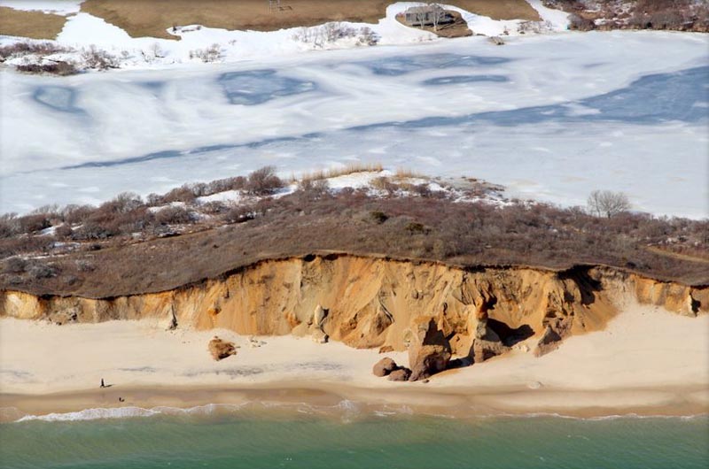
The predawn collapse of the spire at Lucy Vincent Beach last weekend triggered an emotional response. For many it was a moment of reflection, or even catharsis, as the Island trudged through the sixth week of the ongoing pandemic. But despite the magnitude of response, the iconic landmark provided a microscopic glimpse into the vast geological process that once formed the cliffs and is now washing them away.
“In the course of geological change, it’s not even an eye blink,” said Bow Van Riper, Island historian, geologist and research librarian at the Martha’s Vineyard Museum. “Of course it is meaningful in the lives of people who walked on the beach these past decades. But in the grander geological scheme, it is no more significant than sandcastles you makes on the beach that are gone in the next tide.”

The geological process that formed the cliff at Lucy Vincent starts quite literally at the beginning of time on earth. But to shave a few billion years, Mr. Van Riper decided to start the story roughly 21,000 years ago.
Geologists talk about the most recent era in earth’s history as a series of ice ages separated by glacial periods. In the most recent cold period, which reached a climax 21,000 years ago, glaciers had spread from the northern tip of Canada down to Manhattan, extending as far west as where the Vineyard and Nantucket are now.
“We are talking about a sheet of ice roughly a mile thick . . . imagine a bulldozer with a blade a mile high, pushing a gigantic ridge of dirt and rocks and boulders in front of it,” Mr. Van Riper said. “As it moved southward, it exerted an incredible force, capable of moving boulders along the earth like a kid kicking a soccer ball.”
The glaciers had caused sea levels to drop, pulling in water and securing it in the form of ice. The shoreline 15,000 years ago would have stretched many miles south of where the Lucy Vincent shoreline is today. Gradually, as the climate changed from cold to warm, the front end of the glacier began to melt. Geological matter that was scraped up and dumped by the ice sheet was left behind, forming the sprawling ridges that today run from Gay Head along the south shore to Lucy Vincent.

As the glacier retreated, sea levels began to rise. Around 5,000 years ago, a lumpy triangle surrounded by water on three sides remained. This was Martha’s Vineyard.
The glacial retreat washed out fine particles of sediment, leaving behind the chunks of clay, gravel and silt that form the up-Island cliffs along the southern facing shore today. The wash of sediment accounts for the unique geology of the Lucy Vincent cliffs — the broad region where the ridges met the outwash plain.
“If you set up a time-lapse camera on top of the cliffs 21,000 years ago and let it run . . . what you would see is the ocean appear over the far southern horizon and get closer until it is where it is now, lapping up against the base of the cliffs,” Mr. Van Riper said. “From that point on, the story of the cliffs on Lucy Vincent has basically been the ocean nibbling at the base, undermining the cliff and leading the top of it slumping down towards the beach. If you’re not careful, it will take your road, lighthouse or multi-million dollar house with it.”
For the next few thousand years, waves continued to beat against the cliff, swirling around the sides and scouring the circumference of the base. The weight of the enormous slab of sand and rock, packed by silt, eventually formed fissures. Gradually, each of those fissures separated, transforming the cliff into a series of pillars that split away. Once the pillars were separated, more of the open area was exposed to wind and wave action, making it more vulnerable to erosion. With waves washing around the side of the pillars and rain trickling through the cracks, the cliff was whittled away from the outside, culminating in what almost seemed to be an illusion — a freestanding pillar that looked as if it had crawled from the face of the cliff behind it.

In the 1960s, when Lucy Vincent was a living person and the area was colloquially known as Jungle Beach, the cliff expanded from grassland to the shoreline, creating a barrier separating nude bathers from clothed ones. In the last two decades, erosion shaped an arch where beachgoers went to escape the sun, blissfully unaware of the risk it posed.
And long before the hippie era, the cliff was a precipice seen mostly from above.
“Lucy Vincent owned the beach. She didn’t go near it and she didn’t let anyone else go near it,” said Jane Slater, a distant relative of the Chilmark librarian who later gave the beach to the town. “Once a year she took us to the cliffs to look down. They were too high, she thought they were dangerous,” Mrs. Slater recalled.
Long before that it was a spot frequented by native Americans. A 1995 Harvard University archaeological survey unearthed human remains, a spear point and other cultural artifacts dating back 10,000 years.
“It was certainly a sacred place,” said Bettina Washington, historic preservation officer for the Wampanoag Tribe of Gay Head (Aquinnah). “There was time before that spire fell, and there

will be time after. It’s just a marker for the passage of time.”
Mr. Van Riper said geological change is a fundamental principal of living on an Island, where land and sea are constantly toiling against each other. Sand is eroded in one place and deposited in another. Cliffs collapse and change their contour. It is a natural process as common as snow falling in the winter and melting away in the spring, on a much larger scale.
“This feels meaningful because we admired this particular chunk of cliff, so we noticed when it was gone,” Mr. Van Riper said. “But if you went back to that very spot, turned your back to the sea and look at the cliff in front of you, you would still be looking into a thick mass of sand and silt and gravel that has been scraped up by the glacier, smooshed down and left behind when the glacier retreated.”
He added: “The next big storm will start the process of undermining the cliff and potentially shearing off another layer . . . causing another pillar to lean away from the cliff all over again.”


Comments (5)
Comments
Comment policy »