

Peter Wells, owner of the Chappaquiddick Ferry, admitted last week that he’s looked into the inclusion of amphibious vehicles to service the ferry in case of emergencies, as rising seas threaten vital infrastructure in the town of Edgartown.
The issue arose during a final Zoom presentation of Edgartown’s Climate Change Vulnerability Assessment and Adaptation Plan, which identified the Chappy Ferry as one of the most vulnerable parts of the Edgartown Harbor.
“We’ve inherited a Chappy ferry system that is not the only way to get people across the water,” Mr. Wells said during the meeting. “I think [amphibious vehicles] are something worth looking into, especially in an emergency situation.”
Presented after two years of study and compiled by the Woods Hole Group in a more than 500-page report, the plan originated from a 2019 state grant the town received to examine risks posed by sea level rise, storms, flooding and climate change.
One of the actions the group endorsed was elevating the Chappy Ferry ramp six inches, as proposed by th town’s ferry steering committee. A six-inch increase to the ramp on the Edgartown side will make the ferry level with the Chappaquiddick side, which has seen significant tidal and storm flooding in recent years.
“That’s what buys us the time, when we add six inches to the ramp on the Edgartown side. That’s going to solve a lot of our fair weather flooding problems,” Mr. Wells said. “It’s not going to solve the storm tide stuff.”
In 2018, Edgartown was designated as a Municipal Vulnerability Preparedness certified community by the state, qualifying it for the grant and extensive study. Joseph Famely, the climate and sustainability team leader, presented the findings last Wednesday.
“One of the top priority actions for the town was . . . to do a detailed coastal vulnerability assessment to look at, among other things, town infrastructure, the impacts of specifically, sea level rise and coastal storms on the town, that rose from, the planning process, but also was sort of reinforced by recent experiences in some pretty severe 2018 storms,” Mr. Famely said.
The Woods Hole Group used advanced storm tide mapping technology, coastal inundation modeling and risk assessments to detail the most climate-vulnerable locations in Edgartown. Along with the Chappy Ferry, high-risk locations included a handful of piers on the Edgartown harbor, the Dike Bridge on Chappaquiddick, the harbor master parking lot and the Edgartown Yacht Club, which was raised two feet in 2019.
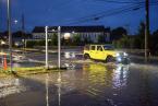
Dock street and Main street were identified as the two roadways at the greatest risk during storm surges.
A striking takeaway from the presentation was that the projected 2050 mean high water flood condition of four feet is “almost equivalent” to the storm surge water level observed during the March 2018 winter storm Riley.
“So where you saw flooding coming up halfway up Daggett street from the ferry, across Dock street and the Dock street parking lot, that storm surge condition that you experienced could one day become the daily condition or the on average daily condition,” Mr. Famely said.
But the projected rising sea levels presented immediate concerns for the Chappaquiddick ferry infrastructure.
“The ramps are an issue in the near term. Obviously, the other controls and equipment are less vulnerable in the near term. Certainly all of this is vulnerable to the storm surge,” Mr. Famely said.
Although it was the final meeting for the study, community members urged both the Woods Hole Group and the town to get the word out about the study’s findings. The full report can be found here.
“The state definitely advocates for getting the word out, public engagement, so there may be some opportunity down the road to apply for funding to do just that,” Mr. Famely said.


Comments (4)
Comments
Comment policy »