

Hurricane Sandy is being characterized as the worst storm in recorded weather history to hit the Northeast, worse than the 1938 hurricane.
And while the Vineyard was at the outer edge of the huge, historic storm and escaped the most severe conditions, weather data provided by the National Weather Service shows that wind speed, storm surge and barometric pressure were near hurricane strength, even on the Island.
On Monday as the storm center hovered between Atlantic City and New York city, the National Weather Service measured barometric pressure at 940 millibars, or 27.76 inches. The hurricane of 1938 had a barometric pressure of 946 millibars, or 27.94 inches. The lower the barometric pressure, the larger and more dangerous the storm.
For the sake of comparison, when Hurricane Bob passed east of Virginia Beach in 1991, the barometric pressure was 950 millibars, or 28.05 inches.
The lowest barometric pressure measured on the Vineyard during Hurricane Sandy was at 2:53 p.m. at the Martha’s Vineyard Airport at 983.3 millibars, or 29.03 inches. The highest wind gust recorded at the Vineyard airport was 68 miles per hour, also at 2:53 p.m. Wind direction was from the east.
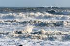
The highest wind gust recorded in the area by a weather service device was measured at the Buzzards Bay entrance light tower. The wind there reached a gust of 83 m.p.h. at 3 p.m.
Kim Buttrick, a meteorologist, with the National Weather Service in Taunton, said what was most striking for meteorologists was not only the huge size of the storm but its movement. It is rare to have an Atlantic storm move due west, Ms. Buttrick said. Southeastern Massachusetts, Rhode Island and Connecticut all experienced similar conditions and were all spared the worst of the storm. “I was amazed. We dodged a bullet. This was the worse case scenario for New York city and Atlantic City and all points in between,” the meteorologist said.
The large geographic size of the storm meant it was felt on Vineyard as early as Sunday morning. “The storm was well south of this region and already the surge was being noticed,” Ms. Buttrick said. She recalled a telephone conversation she had Sunday morning with a Steamship Authority captain for the ferry Martha’s Vineyard.
“I called and they were reporting a high tide earlier that morning of 3.4 feet, that was predicted. But two hours later, at 9:30 a.m., the tide was still 3.4 feet high, and it had not gone down. They were already starting to feel the effects of the storm surge, and having difficulty getting trucks on and off the ferry,” she said. “They were turning semis [tractor trailer trucks] away,” she said.
Wave height in this region was difficult to measure, but the Nantucket Shoal buoy (which is southeast of Nantucket) recorded a wave height of 34 feet on Monday afternoon, according to Mrs. Buttrick.
There is no formal device for measuring storm surge on the Vineyard. However, at the Edgartown Yacht Club, a building perched over the Edgartown harbor, the staff keeps a record on the clubhouse wall of extreme high tides going back to the 1938 hurricane, when the water mark was 43 inches above the floor. During Hurricane Sandy the yacht club measured the water at 17 inches above the floor. That is just under Hurricane Donna from Sept. 12, 1960 and two inches lower than Hurricane Bob, which left its mark on the yacht club wall on August 19, 1991. The mark made for a hurricane in 1944 is 56 inches above the floor.
The lack of rainfall on the Vineyard during the storm is worth noting. In four days of measuring, the Vineyard received .84 inches at the National Weather Service Cooperative Station in Edgartown. The two wettest days came after the storm center had passed over land. Total rainfall for October was 3.52 inches, only a fraction of an inch above the monthly average of 3.39 inches.


Comments
Comment policy »