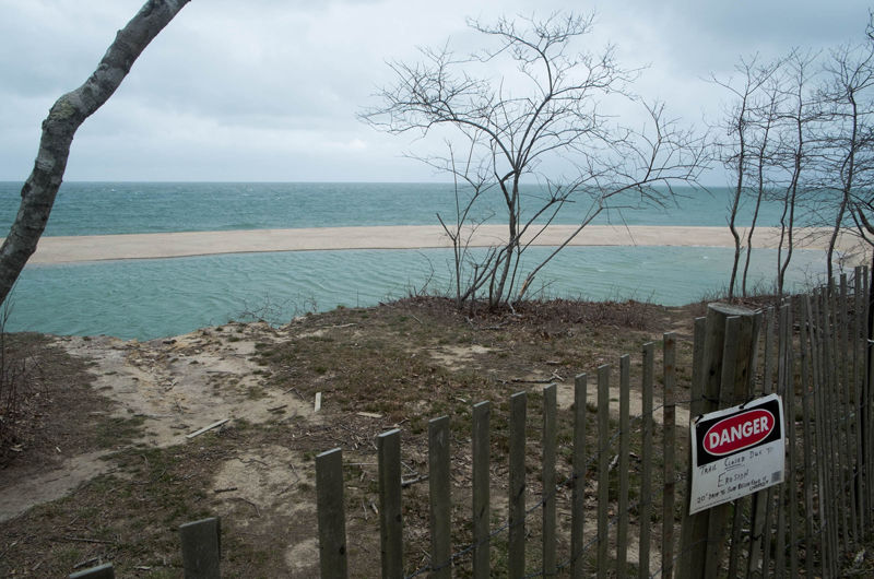
A little more than seven years ago, Norton Point Beach broke free from Chappaquiddick.
As a result of that Patriot’s Day storm, Chappaquiddick became an island of its own, and an inlet formed off the coast of Wasque. Although it felt like a dramatic change at the time, disrupting commutes and over-sand vehicle excursions, many have come to see the breach as part of a cycle that has repeated itself over time.
According to Gazette records, there have been several breaches at that point over the last 150 years. Following the previous lasting breach at Norton Point, which took place in 1953, a small saltwater pond formed west of Wasque point. The memory of that pond resurfaced this month, as a small pond formed in roughly the same place, nicknamed Little Swan Pond.
This time, though, more people are watching and more advanced technology is available to record the changes occurring on a daily basis.
As it has for a few years, the barrier beach is gaining sediment and plodding eastward from Katama toward Wasque Point in what many believe will be an eventual reconnection with Chappaquiddick. History seems to be repeating itself out there, according to the keen observation of local residents and scientists who study the transformation of the coastline and its surroundings.
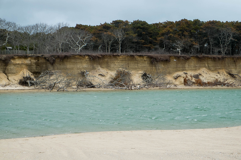
The changes are dramatic at Wasque, most notably the loss of 30 to 40 acres of upland that belongs to the Trustees of Reservations. People come to the property now and tell superintendent Christopher Kennedy, “I must be in the wrong place. This just looks completely different.” They don’t recognize the beach they once enjoyed before erosion took its toll. In five years, a parking lot that once stood on solid ground has become enveloped by the sea. A board walk that extended 700 to 800 feet out to the shoreline is now just a memory of convenient beach access.
It’s this continual state of flux that draws scientists here to study. Researchers have developed great interest in the spot because rapid changes can be observed over the course of just a few years. But perhaps the changes have been studied most intensively by the citizen scientists: Islanders who meticulously record what is occurring between the points.
One is Robert Gilkes, a Chappaquiddick ferry captain who records the ocean’s encroachment with wooden stakes and a global positioning system. Another is Skip Bettencourt, who flies his camera drone above the breach, taking live images of the changes as they occur. Mr. Gilkes shares his measurements with the Martha’s Vineyard Commission and Woods Hole scientists, and Mr. Bettencourt shares his aerial photographs with many via the internet.
Coastal scientists say they rely on these and other folks to perform their research.
“We are told this is the typical evolution of the inlet,” said Britt Raubenheimer, a physical oceanographer with Woods Hole Oceanographic Institution. “A lot of the details we knew from talking with locals.” When Ms. Raubenheimer and colleague and husband Steve Elgar wanted to find the deepest point in the Edgartown channel, they turned to harbor master Charlie Blair.
And Mr. Blair knew exactly the spot; he’d been asked to locate it for the filming of Jaws back in the 1970s.
“You can study books forever, which is what we do, but local people have a lot to contribute,” Mr. Elgar said.
Another avid citizen scientist is Dana Gaines, a Chappaquiddick property owner who was a child during the previous opening of the channel. Mr. Gaines remembers learning to swim in the former swan pond in 1963. Still, he said the area has changed. The cliffs are far steeper now than they had been before, and Mr. Gaines wonders if the area is in fact at the same point in the cycle. “We have been trying to figure whether it is following an identical pattern or whether there are some variations,” he said. The progression underway, where Norton Point overlaps the swimming beach and keeps building toward Wasque Point, certainly bears resemblance to previous movements during previous breach times. “My gut tells me if that pattern continues that this huge beach that has formed on the Chappaquiddick side that has the pond, that beach will be washed away with erosion,” Mr. Gaines said. He thinks that once the breach closes, a robust beach will return, as well as another swan pond. “It is sort of exciting yet tragic and humbling to watch the rapidity of the changes. It is nature at work.”
The elements at Norton Point are engaged in a constant game of musical chairs — the barrier beach moves eastward toward Wasque, sediment shifts to form a small shoal inside the breach and upland disappears by the acre. Fishermen still gather at Wasque, where small fish caught in the inlet’s current attract striped bass and bluefish. The breach is reliably open for now; a healthy flow of water going through it with every tide.
But that may change within months or years.
When the breach occurred, it interrupted the normal transport of sand to the beach, exacerbating erosion, said Greg Berman, coastal geologist with the Woods Hole Sea Grant. The area has one of the fastest erosion rates in the state, which is due to the formation of the inlet that channels a strong current, he explained. “When the inlet finally seals up again, all that material that has not been able to make it to the east, will make it there again,” Mr. Berman said.
In 2009 and 2010, the barrier beach grew rapidly, at a rate of 1,000 feet per year, he said. Once the point had migrated toward the Chappaquiddick side, though, its growth stalled as it approached the closing point. There is still enough of a current flowing through the inlet to preserve the opening. But in time, this may change. “It’s really just time and sand,” Mr. Berman said. “It’s really hard to say exactly when it’s going to close.” Historically, he said breaches have lasted 15 to 17 years at Chappaquiddick. “This certainly isn’t the first time this has happened, and it’s probably not going to be the last time either,” Mr. Berman said. Even if the breach does close soon, “you are going to need a fairly substantial plug to close it over the long term,” he said.
In the years since the erosion began, Chris Kennedy, the Trustees superintendent, figures he’s moved the fence barring entry to the beach from the fisherman’s parking lot back close to 15 times. “I’ve become an expert at moving fences,” he said.
The trees aren’t as lucky.
Mr. Kennedy must remain unattached to any form the sandscape chooses to take; an oak tree teetering over the cliff’s edge today will be thrown overboard tomorrow. White oaks and pitch pines stand precariously on the edge of the fisherman’s parking lot, their roots clinging to the cliff’s crust. Mr. Kennedy said there are still hundreds of trees that will fall over the edge, just one of many upsetting things about the changing landscape. “People have a strong sense of place here,” he said. “Change is inevitable; it happens everywhere. It’s just that it happens faster here than other places.”
It’s happening a little too fast for comfort at the abutting property owned by Sue and Jerry Wacks, where a small home stands 20 feet from the cliff’s edge. Recently, the owners installed hundreds of sandbags along the side of the cliff to stave off further erosion. Below, the unrelenting wind forming whitecaps in the sea, the current tugging at the base of the cliffs.
“When you look at this, it makes you wonder, is this the future of Martha’s Vineyard?” Mr. Kennedy said.


Comments (2)
Comments
Comment policy »