
On a bright, cloudy morning this week, a few fishermen stood in waders and T-shirts at Wasque Point and cast quietly into the surf. The popular fishing spot at the eastern tip of the Island has been the subject of ongoing study in recent years, as wind, waves and tides create one of the most dynamic coastal systems in the state.
Just a few hundred yards from the surf, the well-known Schifter house loomed above the beach as bank swallows zipped in and out of their holes in the eroding cliffs below. Between the cliffs and the ocean, a new pond has formed where the 8,000-square foot house once stood.

Three years ago, in the face of rapid erosion — accelerated by a dramatic breach that formed in the barrier beach in 2007 — the brand-new house and other buildings were moved 275 feet inland and temporarily saved from the sea. Erosion has slowed at Wasque since around 2014, but will most likely resume in the future. The Schifter house has become something of a monument to the hazards of building near the shore.
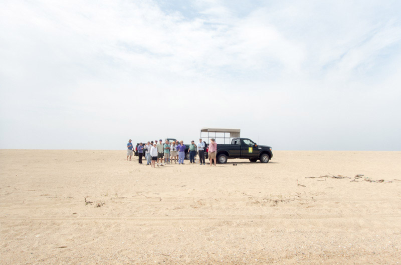
A group of scientists, coastal planners and others piled out of two pickup trucks just south of the cliffs and stared up at the house. Several of them had taken part in the Martha’s Vineyard Coastal Conference the day before, which dealt largely with the recent changes at Wasque and Norton Point to the west. They included Greg Berman of the Woods Hole Sea Grant Program and Steve McKenna of the state Office of Coastal Zone Management, who organized the conference, and others from on and off the Island.
“We are in theory standing on the Schifter property,” said Chris Kennedy, director of the Trustees of Reservations, which owns and manages a good portion of the outer beaches on Chappaquiddick and who led the tour on Tuesday. Only a fraction of the original five-acre Schifter property remains intact above the cliffs, Mr. Kennedy said, and access to Trustees property on either side of the beach requires an easement over the private land. Fortunately, Mr. Schifter himself is an avid fisherman and has not interfered with the surfcasters in his new backyard.
It was a beautiful spring day in 2007 when the breach formed, Mr. Kennedy said, although a northeaster had recently turned a portion of the barrier beach farther west to mud, and Katama Bay had built up enough of a head to break through to the sea. Over the next few years, the breach widened to about a half mile before gradually migrating west and closing at Wasque, as it typically has in the past.
The south coast of Chappaquiddick represents a rare convergence of coastal processes, including a barrier beach, tidal channels and dramatically shifting sands. Steve Elgar, a senior scientist at the Woods Hole Oceanographic Institution, ran through some of the highlights during his talk at the conference. He likened the area to a giant washing machine that never stops. A zone of calmer water where Muskeget Channel separates from Vineyard Sound has gradually moved closer to the point.
But scientists still have only a vague sense of what has caused the breach to heal as quickly as it did beginning around 2013. Mr. Elgar said the extent of sand movement along the point appears to be influenced more by the angle of the point, rather than whether the breach is open or closed. “When that corner is sharp, there seems to be a lot more sand moving around,” he said. “When that corner is smooth, not as much.” But what determines the angle is also something of a mystery.
A huge amount of material at Wasque and Norton Point to the west was torn away during the eight-year breach. Since 2012, the Martha’s Vineyard Commission has conducted four surveys of the area, tracking 237 feet of erosion of the cliffs at Wasque point. The most dramatic changes occurred in 2012, Martha’s Vineyard Commission cartographer Chris Seidel said at the conference. By 2013, the shoreline had engulfed the earlier Swan Pond, and the Wasque cliffs stopped just a few yards from the Schifter house.

The breach finally closed last April, and Katama Bay, which separates Chappy from the rest of the Island, now tapers to a long point between the beach and the receding cliffs. The small pond where the sand has pinched off the eastern tip of the bay has again been named Swan Pond, although the swans themselves have yet to arrive. The barrier beach has remained relatively stable since 2014, and the breach hasn’t reopened since February.
But this is just one phase in a constant pattern of change that will likely continue with greater frequency as the sea level rises. When the next breach will occur is anyone’s guess, but Mr. Kennedy is hedging his bets. “It will almost certainly be sooner than the 40-year gap that we saw last time,” he said, noting that houses along the shore can’t be moved back forever. “It behooves us to ask, what is plan B?”
Stands of cedars along the cliffs helped slow some of the erosion, but many of those trees have toppled down to the beach. Just west of the Schifter house, large stands of cedars have turned bare, suffering from root exposure. Still farther west, mats of beach grass and their shallow roots have slumped down onto the cliffs. And portions of the massive sand-filled sacks that failed to protect the Schifter house lie scattered along the beach where they were left by the tides. Mr. Kennedy pointed out a former parking lot that once held 150 cars. “The parking lot is mostly underwater,” he said.
The group stopped again about a quarter mile west of the point, just across the bay from the smaller Wacks house, now perched about 21 feet from the edge of Katama Bay, on a cliff just beyond the barrier beach. The threat here came more from waves than from the wind, and the remains of burlap sandbags are still embedded in the cliff. What finally saved the house in 2013 was the barrier beach itself, which regrew in fits and starts, sometimes covering hundreds in a few days, and eventually blocked the waves.
Both of the threatened houses along Norton Point remain occupied on a regular basis, Mr. Kennedy said, but their days are numbered.
“There is no question that in the next breach this house will have to be removed,” he said of the Wacks house, since the Trustees do not allow buildings to be relocated onto their property. “If mother nature is going to take it, mother nature is going to take it.” Barrier beaches are naturally changing systems, he added, so as a rule the Trustees do not armor the shore. During the breach, they encouraged people to observe the changes underway, although the only route to Wasque Point was over sand or to walk from a parking lot a mile away.
Despite the damage to private property, the breach has greatly benefitted both Katama Bay and the barrier beach. More flushing through the southern inlet of the bay meant healthier and more abundant oysters, and the closure has created acres of new shorebird habitat. “You could say this had a negative effect, but from an ecological perspective, it’s almost like hitting the reset button,” Mr. Kennedy said.
Besides the new bank swallows, the area is still home to piping plovers, black skimmers and a variety of other shorebirds. Hundreds of least terns were swarming the spot just beyond the Wacks house where the breach formed. The colony may now be among the largest in the state.

As the barrier beach continues to restabilize, beach grass has taken root and is reforming the dunes that were once up to 20 feet tall. That process will mean less habitat for nesting shorebirds, but could also open the door to northeastern tiger beetles and other species.
The Trustees hope to reinstall a set of stairs leading down to the beach west of the point, although they know anything they build there will be temporary. “You really have to be flexible in how you manage these properties,” Mr. Kennedy said, again noting the changing nature of the barrier beach system.
In general, he sees the breaches as both natural and beneficial. But they have also fueled concerns about continued development near the coast, which was another topic at the conference. Speaking about the likely effects of climate change on the Island, Andre Martecchini of the engineering firm Kleinfelder took aim at federal disaster relief funding and subsidized insurance rates. Among other things, he said the Federal Emergency Management Agency would need to rethink its approach of rebuilding houses in the same spot after a storm.
“The flood insurance, first of all, has to stop,” Mr. Martecchini said. “And post-storm these agencies really have to start saying, ‘We are not going to fund business as usual.’” (Both the Schifter and Wacks houses were above the 100-year floodplain.)
By afternoon, a light fog had rolled in and the group headed back up the beach, past the fishermen and the foreboding Schifter house and the flittering bank swallows below. Back on solid ground, Mr. Kennedy again stressed the importance of a long-term approach to shoreline management. The breaches at Norton Point will no longer be a once-in-a-lifetime event, he said. “It’s going to happen much more often.”
See more pictures from scientist field trip to Wasque, Norton Point.


Comments (6)
Comments
Comment policy »