
It is one thing to live on an Island. It is quite another to do so as the sea rises, storms get mightier and the rain falls harder and more often. We’re getting pummeled from every direction. Our roads and harbors are increasingly hard hit. An October northeaster that brought heavy downpours left parts of Beach Road in Vineyard Haven underwater.
Getting around during coastal storms is becoming a challenge. In Oak Bluffs the roads by Farm Pond and Crystal Lake routinely blow out in storms. Dock street in Edgartown floods regularly. And it could get worse. If one of the up-Island overpasses gives out in a storm, the town of Aquinnah will be inaccessible, as happened in the hurricane of 1938. There are 16 dams in West Tisbury and Chilmark that could fail in foul weather.
Heavy rain causes inland flooding. Beach Road near the Edgartown Triangle, and until recently, County Road in Oak Bluffs are two such areas.
The water is rising. Where will the On Time land when Chappy Point disappears? How will ferries dock in higher seas? What happens when the harbors overflow?
Whatever solutions arise, the face of the Island will change. And we are on the cusp of some heavy decision-making.
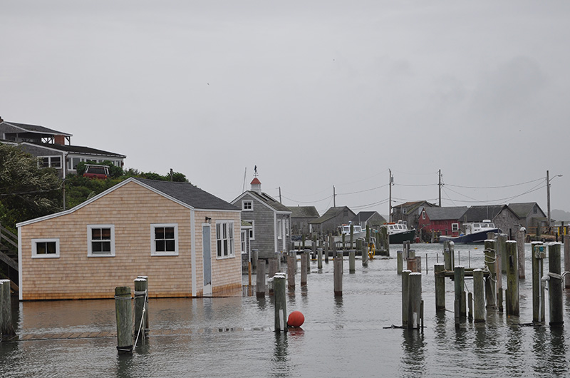
In Oak Bluffs, the harbor master hopes to realign the southern jetty to protect the harbor in northeast storms. Another idea is a hurricane barrier.
An adaptation plan prepared for the town suggests raising the harbor bulkhead and building up the beach in front of the harbor. The bulkhead would consist of thick aquarium-style glass to maintain water views. The bulkhead at private harbor front property would also have to be raised. This plan would help protect Lake avenue, the lower downtown, harbor businesses and the Camp Ground, all of which are keys to the local economy. Is this far-fetched or forward-thinking?
Perhaps the biggest transportation challenge is Beach Road in Vineyard Haven and Oak Bluffs. It is low-lying and sits on a barrier beach — a beach system with water on both sides. The road links the two down-Island towns. Most importantly, it is a major access to both our Island lifelines, the year-round Steamship Authority port in Vineyard Haven and the Martha’s Vineyard Hospital. Portions of the road will be permanently underwater in a foot and a half of sea rise — a couple of decades from now — and intermittently until then.
Beach Road, owned by the state, is also home to private residences, businesses and a new $47 million drawbridge.
What are the adaptation options?
One is a long, high seawall. But seawalls destroy the beach in front of them and cause erosion at the points where they eventually end. The state frowns on hard structures like seawalls on barrier beaches.
The road could be raised or the bridge lengthened, but how would the property owners get to their low-lying homes?
The obvious answer is to retreat from the road. (I can already hear the uproar.) It will happen eventually, but the state is unlikely to abandon its costly new bridge any time soon.
Another option, purely theoretical at this point, includes property buyouts. Some entity, the government or a nonprofit, buys the beachfront homes — and allows the owners to live in them for an agreed upon time — then takes them down and restores a beach and dune system. A well-maintained beach and dune will help protect the road while the new public beach will provide recreation. The houses could be moved to higher ground and made affordable. Raise the causeway and businesses, channel the stormwater into vegetated swales and lengthen the Eastville Point breakwater.
Will this concept work here, with our ferocious off-season storms and anticipated above-average sea level rise? The short answer is we don’t know. The point is that creative ideas are worth pondering.
We can look to the Netherlands for insight. The Dutch have been dealing with water for centuries and know a thing or two about how to live with it. To protect one coastal region they built a long, high dune. It was so large they built a parking lot underneath it.
Dutch water management concepts are fast taking root in the United States. Boston scrapped the idea of building a huge seawall and will instead add waterfront parks, elevate vulnerable sites and restore tidelands. Other places are returning flood plains to their natural functions, building earthen berms topped with walking trails, and planting gardens that act as retention ponds in storms.
The goal of these types of projects is threefold: channel the water where you want it to go, improve public spaces for the community and add economic value to the sites.
Although our roads and harbors need serious attention, the good news is that big challenges provide big opportunities.
It’s time for the Island community to begin weighing in on how to build a climate resilient future. The Martha’s Vineyard Commission’s climate action task force is working on an Islandwide climate adaptation plan. Public participation will be a critical component. Stay tuned.
Liz Durkee lives in Oak Bluffs.


Comments (4)
Comments
Comment policy »