
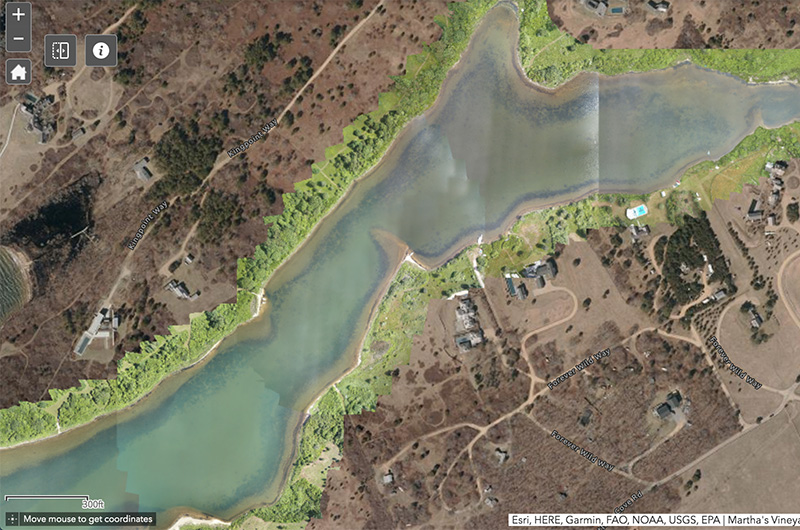
Stitching together nearly 1,500 high-resolution drone images, the Edgartown Great Pond Foundation has teamed up with the Martha’s Vineyard Commission to produce a first-of-its-kind map of eelgrass in Slough Cove, hoping to gain a better understanding of the vital seagrass in the Island’s coastal ponds.
The map — an interactive, digital mosaic tiled together from 1,430 overlapping aerial drone photos — was made possible by a grant from the Edey Foundation and is part of the foundation’s broader blue carbon initiative to measure how much carbon is stored in the Great Pond and other marine ecosystems on the Island.
It is the first updated map of eelgrass in the pond since 1951.
“This is kind of cutting edge,” foundation executive director Emily Reddington said. “It’s sort of a methodology project, but it opens up incredible opportunities for the future.”
Speaking to the Gazette last week, Ms. Reddington, foundation watershed outreach manager David Bouck and MVC cartographer Chris Seidel said that the project originated out of a desire to better document the presence of eelgrass — a native seagrass that grows on sandy Vineyard pond bottoms, providing habitat for larval fish and shellfish, sequestering carbon and improving water quality.
Once ubiquitous in the Island’s marine ecosystems, eelgrass had declined precipitously for decades before experiencing a resurgence in the past five years, Ms. Reddington said, prompting the new mapping project.
The foundation decided to focus the mapping on Slough Cove, a narrow eastern finger of the pond that has seen increased development in recent decades, hopeful that it could be used as a model for the rest of the pond down the road.
“Slough Cove has a history of eelgrass impairment,” Ms. Reddington said. “One of the reasons to look at it is to see how that changes over time, as restoration continues. So Slough Cove was a really ecologically interesting site, but also physically, because it’s a contained unit. And those two things work together as part of a longer-term monitoring plan.”
The foundation decided to enlist the help of Ms. Seidel to conduct the mapping, using small Unmanned Aerial Sytems (sUAS) technology — in layman’s terms, a drone — to take the photos over a series of five days in June and July of 2020. Ms. Seidel, with the assistance of Great Pond foundation scientific program manager Julie Pringle and others, would fly the drone in a grid-shape, taking photos just below a 200 foot elevation.

“It’s sort of like mowing the lawn,” Ms. Seidel said.
Normally done on a much smaller scale, the drone mapping technology was stretched over the entire cove — a first for Ms. Seidel, who is an experienced cartographer. She then used software to seamlessly stitch the images together, overlapping them by 80 per cent to account for minute differences in water surface, sunlight and weather, like fog. The entire process resembles putting together a 1,500-piece jigsaw puzzle, except the colors are uniform and there are no connectors.
Past images of eelgrass in Island ponds have been conducted through state aerial flyovers, with pixel resolutions ranging from a meter to six inches. But because of its low flight elevation, the drone provides 0.6-inch pixels, allowing GIS software to create a much higher-resolution, detailed map of the cove’s eelgrass.
Experts said that the drone technology could be cheaper and more efficient than previous mapping techniques on a larger scale, providing ecologists with a more realistic way to extrapolate their findings to other parts of the pond or Island, plan for dredge openings and set more accurate nitrogen limits. In other words, the many smaller pictures are better for the big picture.
“The future of watershed management is just taking that zoomed out, ecosystem level view, instead of focusing on one species or focusing on one habitat,” Mr. Bouck said. “You have to look at the big picture and how it all kind of fits together.”
Contemporaneous with the Slough Cove project, the state DEP used flyover technology to map the Island’s south shore ponds last year. Although the images are not yet available, Ms. Reddington said state officials were excited to compare their work with the drone map.
“Right now, most of the seagrass in New England is mapped by plane,” Ms. Reddington said. “But if you could figure out a way to use those techniques together, or one to evaluate the other, it’s a really exciting possible new field.”
After the images were compiled, Great Pond foundation staff ground-truthed the map with state data, and worked out a formula to determine the amount of carbon stored in Slough Cove’s approximately seven acres of seagrass meadows. Depending on analysis methods, Mr. Bouck estimated that the cove alone stores between 418 and 523 tons of carbon.
Seagrass and coastal ponds are four times more efficient for sequestering carbon from the atmosphere than forests, and store carbon twice as fast, Ms. Reddington said. Although that doesn’t diminish the significance of land-based conservation, Ms. Reddington said the findings add perspective on the importance of restoring marine ecosystems.
The seagrasses of the world have declined by 40 per cent since the 1970s, Ms. Reddington said.
“If you’re getting the choice to conserve an acre of forest or an acre of seagrass, you’re going to get a lot more bang for your buck with your seagrass,” Ms. Reddington said.
More information on the EGP Foundation’s Blue Carbon initiative and the eelgrass mapping project can be found on its website.


Comments (6)
Comments
Comment policy »