
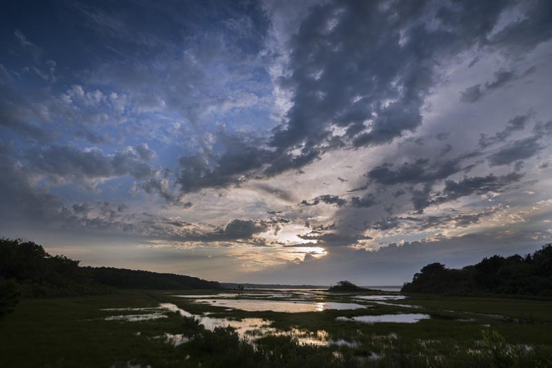
By the year 2070, salt marshes on Martha’s Vineyard are expected to decrease by nearly 200 acres as sea levels rise, forcing shorelines and floodplains inland and threatening homes and vital ecosystems that have existed for generations.
That’s roughly the equivalent of losing half of East Chop — or six Camp Grounds worth of gingerbread cottages.
The Martha’s Vineyard Commission has been working with the state Coastal Zone Management (CZM) agency to map the expected changes at locations across the Island — from Squibnocket Pond to Sunset Lake — so Vineyarders can better visualize and understand the impacts of wetland migration in their own backyards.
Using data from CZM’s Sea Level Affecting Marsh Migration (SLAMM) model, commission special projects planner Dan Doyle and cartographer Chris Seidel have put together about a half-dozen story maps through GIS technology that illustrate how the Island’s wetlands are expected to evolve and migrate inland over the next 50 years.
The maps, now available online and made possible by a 2019 Edey Foundation grant, paint a picture of an Island with 125 miles of rapidly-changing shoreline and coastal ecosystems that will be transformed as marshlands recede and regularly flooded wetlands take their place, testing crucial services and infrastructure such as the Martha’s Vineyard Hospital and Dukes County avenue, among others.
The SLAMM model bases its predictions on an expected 4.5-foot linear increase in sea levels over the next 80 years. Although it does not account for existing infrastructure, it does use existing topographic conditions, including current ecosystems and shorelines, to assess habitat change.
In an interview this week, Mr. Doyle said the goal of the story maps was partially to show Islanders how wetland migration will occur in the coming decades, especially in areas that have not been developed — and based on sea-level rise, probably should stay that way.
“For as much vulnerability as we have on the Island, we also have a big swath of area where we haven’t developed and we can sort of let natural progression take its course,” Mr. Doyle said. “When you build in wetlands, you don’t have that sponge, that buffer . . . we were hoping to spotlight a few key areas so that people could visualize what’s expected to happen.”
The maps focus on four primary areas: the Lake Tashmoo inlet, Brush Pond near the hospital, Sunset Lake in Oak Bluffs and Squibnocket Pond in Chilmark and Aquinnah, overlaying satellite images with specific varieties of wetlands. Although the SLAMM model includes dozens of different ecosystems, commission staff decided to focus on about seven, dividing the maps into regularly or irregularly flooded salt marshes, transitional salt marsh, freshwater marsh or swamp, beach, open water and dry land.
Each map includes three different overlays, including a baseline overlay for 2020, and then two future overlays for 2050 and 2070. The maps function a little like half-century-long meteorology radars, providing a birds-eye-view, cartographic narrative for the future of the Island’s coastal ecology.
The SLAMM data shows that at most of the four sites, regularly flooded marshland is expected to increase a hundredfold. At Sunset Lake near downtown Oak Bluffs, wetlands are expected to extend to the far side of Dukes County avenue, forfeiting freshwater marsh for a more brackish ecosystem.
But the houses and development across the road will prevent that, creating a different set of challenges.
“The reality is, if you’re in a wetland or marsh, maybe that same marsh migration can’t happen,” Mr. Doyle said. “But at least you know your home, your property, is not the most livable place — that it’s mud hen season every day,” Mr. Doyle said.
Mr. Doyle said towns on the Island could use the model to assess the vulnerability of particular homes in coastal wetlands, and agencies like the Martha’s Vineyard Land Bank could use the maps to determine the long-term viability of prospective property purchases, including land on the Tashmoo inlet. Mr. Doyle also said the SLAMM data is guiding the Oak Bluffs planning board in its pursuit of a district of critical planning concern around Sengekontacket Pond, in order to reserve the area for salt marsh migration.
The Island has more than 3,500 acres of wetlands. But as sea levels rise, the retreat of those wetlands will affect people Islandwide. And it may force human retreat, as well.
“We need to really rethink — and take back the mantle — on what retreat actually means,” Mr. Doyle said. “It’s a sacrifice for the sake of the community, and all the people who are behind those homes.”


Comments (4)
Comments
Comment policy »