
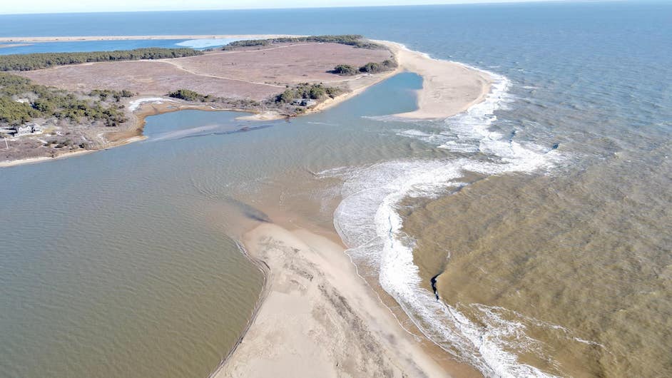
For the first time in more than a decade, a breach at Norton Point beach has officially made Chappaquiddick an island once more.
The thin strip of beach separating Katama Bay and the Atlantic Ocean is owned by Dukes County and managed by The Trustees of Reservations, who sent rangers to inspect the breach on Tuesday afternoon.
After Friday’s windstorm, the area’s sand dunes had been weathered down, Trustees of Reservations Islands director Darci Schofield said, making it more susceptible to a breach. On Sunday, renewed gusts and high tide brought on by the new moon caused the tides to break over the barrier, spilling into marshland near Wasque.
The rangers also found that the water has completely submerged the trail’s fence posts. Both the bayside and beachside trails will remain closed until the water subsides, according to the Trustees.
Trustees park ranger Rick Dwyer has been working on Norton Point for 15 years and was one of the rangers sent to inspect the breach Tuesday afternoon. What was unusual about this breach, he said, was that the opening occurred much further east than in previous years.
The last time a breach occurred at Norton Point was in April of 2007, causing treacherous tides and hampering activity in Edgartown harbor. The incident prompted harbormaster Charlie Blair to assemble an emergency management plan to ensure safe travel ahead of the summer season. Chappy Ferry co-owner Peter Wells even observed a strange phenomenon in which the tides would temporarily reverse, as water flowed out of the breach instead of towards Edgartown Lighthouse.
“A ferry trip could take up to three minutes,” Mr. Wells recalled, compared to the usual travel time of one minute.
Breaches can also pose a threat to the properties that surround them. In 2012, erosion caused by the Katama Bay breach prompted Chappaquiddick resident Rick Schifter to move his house back over 100 feet from the edge of the barrier beach, a monumental feat for the 8,000 square-foot property. Now, he finds himself back at the mercy of the ever-shifting sands.
“It’s too early to know whether to be depressed or not,” Mr. Schifter told the Gazette over the phone.
The last breach did not fully close until 2015, as sand from further up-Island drifted gradually east, depositing in the breach until there was no more water left. This time around, Mr. Wells said the breach seemed to be much smaller and significantly shallower, estimating that it could fill up in a number of weeks.
“Last time, it was so wide it formed a little island in the middle,” Mr. Wells said.
As of Tuesday, Mr. Dwyer did not see any cause for alarm.
“There’s definitely a current going through this one, but I don’t think it will stay as long as the last one,” Mr. Dwyer said. “Time will tell. It may close up on its own.”
For now, he said, there’s nothing else to do but wait.
“That’s about all you can do,” Mr. Dwyer said. “Nobody’s gonna try to fill it themselves.”
Correction: A previous version of the article stated that the last breach occured in May 2007, not April.


Comments (6)
Comments
Comment policy »