
A MEETING OF LAND AND SEA: Nature and the Future of Martha’s Vineyard . By David R. Foster. Illustrations by Brian R. Hall. New Haven and London: Yale University Press. 2017. 336 pages. $40.00, hardback. In bookstores soon.
Thanks to a glacier, Martha’s Vineyard was the last piece of ground to be created in all of New England. Thanks to the rising sea, it will be the first to go.
Setting aside location and beauty, it’s probably fair to ask whether it really matters what happens to the Island, given that the interval between the beginning and the end will probably clock in at something less than 30,000 years, a fraction of a second in geological time.
As if in answer, David R. Foster offers a new book called A Meeting of Land and Sea: Nature and the Future of Martha’s Vineyard. It is an incomparable work, weaving dynamic tales of geology, ecology, history and culture into a vast Vineyard story, one without rival anywhere. This includes our nearest Cape and Island neighbors, whose topography and therefore record of ecology and land use are nowhere near as varied.
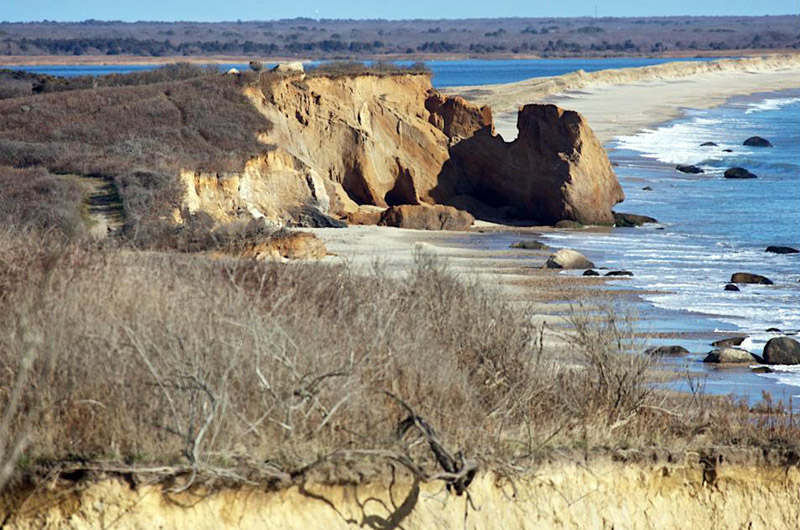
Mr. Foster is a part-time resident of West Tisbury and director of Harvard Forest, a research center associated with the university and based in Petersham. An ecologist known nationally for his work on woodlands, his Vineyard interests extend from the morainal hills to the inland ponds and outward to the shoreline. With the help of his own photographs and a gallery of revelatory maps and charts, in the book he explains how aboriginal and colonial settlers made use of everything on the Island and in the waters around it.

But why a book so broad in scope and yet so narrowly focused on such a small offshore place?
Early on, Mr. Foster makes a startling case, declaring that New England in general and the Vineyard in particular lead the country and even the globe in efforts to save, restore and protect the land, and that the Island can do even more by living actively, companionably and even profitably upon it. With the rest of the Northeast, the Island is uniquely positioned to show the world ways by which it might reverse course ecologically and save itself from . . . well, itself.
The Vineyard has so far conserved fully 40 per cent of its acreage from development, and there are opportunities to save much more. Placed where it is, and managed by devoted inhabitants, the Island can patiently conduct long-term, self-contained experiments in land use and conservation that the rest of the country and planet may one day benefit from, Mr. Foster writes.
The Island has already shown how forests — and the diversity of species they support — can recover after generations of clearing and grazing, he says. Conversely (and perhaps surprisingly, given his record as a woodland scientist) he argues for more farming, given that agriculture can help to keep old pasturelands and ocean views open, working people employed, consumers healthy and the economy diverse. Equally intriguing, he’s a big fan of homegrown timber businesses and leaving uprooted and fractured forests as they are after hurricanes waylay them.
The book carries forward the coastal and Island work of previous authors (among them These Fragile Outposts by Barbara Blau Chamberlain and The Geologic Story, focused on Cape Cod and the Islands, by Robert N. Oldale). But it also stands apart and alone, like the Island so dramatically revealed in its stories, images and charts. It’s an encyclopedia written like an adventure story and illustrated like an art book.
Some of Mr. Foster’s thinking may prove controversial. In essays, talks, and during Island nature walks, he offers theories that occasionally contend with fragmented historical records and current practice.
The reader who accepts his ideas may come to question the use of controlled burns to open and revive the landscape in springtime. (The author generally prefers grazing.) He may wind up doubting the Island nativity of the lost and lamented heath hen, which went extinct here in 1932. (Mr. Foster wonders whether it makes sense to resurrect the species through genetic engineering, an effort now underway.) He may even start to ask disconcerting questions about the legendary first Thanksgiving story over in Plymouth. (Wampanoags did not farm or grow corn until after the colonists arrived, Mr. Foster says.)
And there is one more thing, every bit as compelling as the book itself: a website that offers a wonderful new interactive map of Martha’s Vineyard, based on the work of the great cartographer Henry L. Whiting of West Tisbury between 1845 and 1860.
With a slider, it’s possible to shift back and forth between the beautiful, breathtakingly precise 150-year-old Whiting map and one of four views of the Island today. As the bar moves left and right, towns grow and shrink, shorelines advance and retreat, roads appear or fade into ancient ways, woodlands become farms and farms vanish into forests. With a phone, it’s even possible to zero in on the very ground where you stand and uncover the changes there. (The map, created by Mr. Foster and Jenny Hobson of Harvard Forest, can be found online at mvlandandsea.com/maps.)
A final note and disclosure: I supplied a few pages of historical data to Mr. Foster’s research. I did so with the hope that it would help to bring about something all students of Island history have long hoped for — a geological, natural and cultural story of the Vineyard from the beginning to today, offering with it wise counsel about what we and the world might do with the knowledge and opportunities we now have.
A Meeting of Land and Sea, in company with the interactive map, delivers that story and that counsel in unprecedented, exceptional and immediately indispensable ways.
David Foster will speak on Saturday, August 5 at 1:10 p.m. at the Harbor View Hotel, and on Sunday, August 6 at 12:30 p.m. at the Chilmark Community Center.


Comments (10)
Comments
Comment policy »