
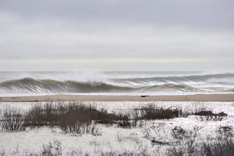
Extreme high tides and storm surge flooding inundated the south side of the Island on Tuesday, washing over coastal dunes, forcing road closures and eroding oversand trails after Monday’s ferocious winter northeaster.

At South Beach in Edgartown, waves crashed over the Right Fork dunes throughout the morning, turning the parking lot into a large coastal pond.
Videos showed water overtaking bike racks, bath houses and lifeguard stands. Town parks and recreation department manager Jessica McGroarty said the flooding was the worst in recent memory.
“It completely decimated the Right Fork dune,” Ms. McGroarty said. “I’ve never seen the water as high. It was flowing into Crab Creek, which is concerning.”
A release from the Edgartown police department said the intersection of Herring Creek Road and Slough Cove Road was closed due to extreme high tides, along with the intersection of Katama Road and Edgartown Bay Road.
The Trustees of Reservations, who manage Norton Point at Katama and own and manage Wasque Reservation on Chappaquiddick, announced that oversand vehicle trails had been closed as well.
“Chappaquiddick [oversand vehicle] trail access continues to be restricted as significant erosion plagues east-facing beaches,” a release said. “Leland Beach is barely passable at low tide; will over-wash at high tide. Back trails are flooded.”
The entrance to Dike Bridge on Chappaquiddick has also been closed, as has all Norton Point oversand trail access.

Trustees director Sam Hart said the entrance to Norton Point had held up fairly well during the storm, but that sand was being pushed back into the nearby salt marsh and causing silting in the Herring Creek.
Mr. Hart said he walked out on the beach as far west as he could and that it appeared about 200 feet of dune had been wiped out by the storm. He said most of the damage appeared to be near the Right Fork.
“It’s stunning,” Mr. Hart said. “It’s a reality we live in every day as a coastal community.”
The storm battered the north side of the Island too. In Vineyard Haven, waves smacked against the Beach Road seawall throughout the storm, occasionally jumping over the concrete. High tides caused flooding along the road, with traffic slowed throughout the day.
Monday’s northeast storm brought 1.44 inches of rain and snow (mostly rain), according to data from the National Weather Service cooperative station in Edgartown. The month of January saw a total of approximately two inches of rain, according to the weather service.
High tide in down-Island towns was at around 4 p.m. Tuesday.


Comments (6)
Comments
Comment policy »