
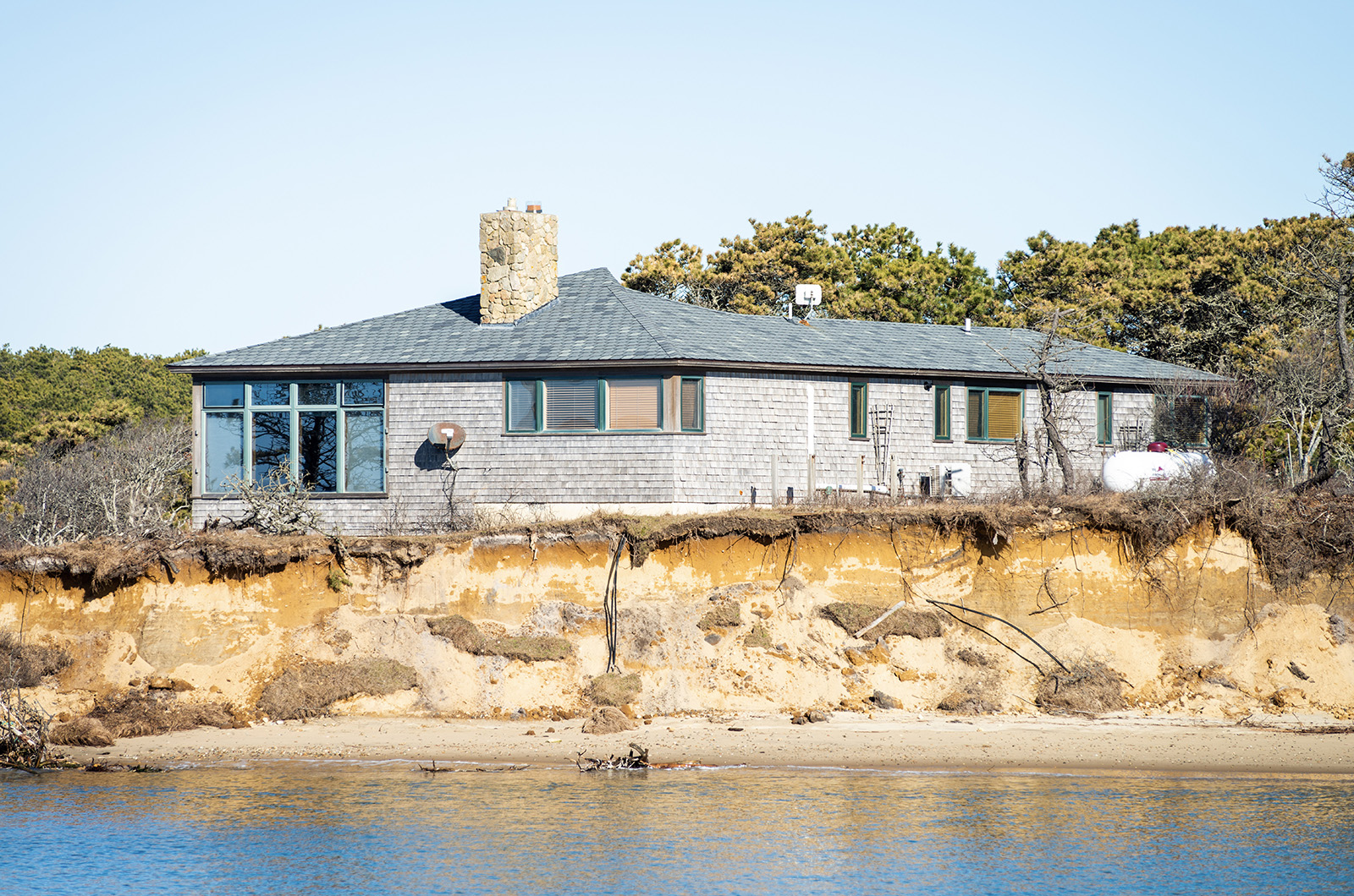
The Chappaquiddick summer home owned by Sue and Jerry Wacks stands as a lonely sentinel by the sea these days. Perched atop a grassy bluff at the western edge of Wasque Reservation, the house is under siege on all sides by the powerful forces of nature that have shaped this dynamic barrier beach for centuries.
And with the recent breach that opened between the Atlantic Ocean and Katama Bay, those forces are now at full throttle.
On Tuesday afternoon this week, the wind blew hard from the west and the beach just below the parking lot at Wasque was deserted. A short distance to the west, flocks of birds swooped and dove over the ocean side of the breach, as fast-moving currents coursed through the opening into the upper eastern end of Katama Bay.
The Wacks house — unoccupied in the off-season — now has an unenviable front-row seat to it all. Just east of the house, the bluff is badly eroded and collapsing in places. On the west, the waters of the breach eat away the sandy beachfront below the house at a rapid clip. Nearby marshlands are inundated by a flood tide.
“I think the Wacks house is in a difficult position. We’ve been in touch with them about the situation and are having conversations about the future of the house,” said Darci Schofield, Islands portfolio manager for The Trustees of Reservations, speaking to the Gazette by phone this week. “A lot is changing very quickly.”
Contacted by the Gazette through a property caretaker, the Wackses declined to comment.
The Trustees own Wasque, a 200-acre conservation refuge at the southeastern tip of Chappy, as well as Cape Pogue Wildlife Refuge, a roughly 400-acre refuge on the northern tip.

Breaches are breaks that occur naturally in barrier beaches running between two bodies of water.
The Norton Point breach opened on Dec. 27 and followed a series of storms that had battered the south-facing shore of Martha’s Vineyard over Christmastime. Throughout the late fall there had been numerous ocean washovers at Norton Point — a roughly two-mile barrier beach that runs between Mattakeeset Creek on the Edgartown side and Wasque on the Chappy side — but no true breach.
Then in late December that changed.
Compared to the last breach, which occurred during a ferocious three-day gale in April 2007 that affected the entire eastern seaboard, this one appeared to tiptoe in overnight. The opening is in a different location, too; the last breach occurred near the western end of the barrier beach, later migrating slowly to the east before finally closing. That took eight years.
The new breach is on the eastern end, posing fresh questions for beach managers and scientists, including what will happen next.
“Based on what we saw happen in 2015, it will migrate eastward,” said Britt Raubenheimer, a senior scientist in applied ocean physics and engineering at the Woods Hole Oceanographic Institution who has studied breaches, including the last one at Katama, along with her husband Steve Elgar, also a senior scientist in applied ocean physics and engineering at WHOI.
Both spoke to the Gazette via Zoom from the West Coast this week.

“It’s natural, there’s nothing we can do about it,” Mr. Elgar said, speaking about the breach. “We’ve seen the natural cycle repeat itself. And it will happen again,” he said.
In recent weeks there has been widespread prognostication about when the breach will close. But with waves, tides and wind all variables, it’s difficult to accurately predict how the breach will behave, the two senior scientists said.
“We don’t know how deep it is . . . it might stay open as the spit gets longer,” Ms. Raubenheimer said, referring to the tail-like spit of sand that forms on the eastern side of the opening. “The spit will grow longer and the opening will grow narrower,” she continued. “But this location is different, the bluffs are unprotected so the bluff around the Wacks house is vulnerable . . . each storm is going to eat into that bluff a little more.”
And given the dynamic nature of the area, conditions can change quickly, the scientists said.
“During the last breach we could see it change sometimes a meter in an hour . . . Where it is now, I don’t know how long it will take it to close,” Ms. Raubenheimer said.
“There’s a lot we still don’t understand about these cycles,” she added.
One factor will be the size of the ebb shoal — a shoal of sand that forms on the ocean side of the breach, Ms. Raubenheimer explained. “The waves put the sand back into the opening during a flood tide,” she said.
•
The rapidly-changing conditions at Norton Point and Wasque come precisely at a time when the landscape is also changing for how the beach will be managed, beginning this spring. Spurred by the town of Edgartown, the Trustees decided late last year to not renew their longstanding contract with the county to manage Norton Point beach. After March 31, the town intends to take over management of the beach, although the details have not been finalized.

It’s even unclear at the moment whether the breach lies on property owned by the Trustees or the county.
“There’s a question about where the boundary line is,” said Cynthia Dittbrenner, director of coast and natural resources for the Trustees. “We will work with Edgartown to figure out who’s responsible, and if work can even be done out there,” she added.
Ms. Dittbrenner underscored the unique nature of the beach.
“Norton Point Beach is one of the most dynamic beaches in all of New England,” she said. “It’s constantly changing.”
And migrating.
A climate change study commissioned by the Trustees with the Woods Hole Group in 2021 mapped the historic northward migration at Norton Point, showing that the beach has migrated 1,500 feet to the north over the past 125 years. That’s a distance greater than the Empire State Building if it was laid on its side, Ms. Dittbrenner said.
The beach is also prime habitat for migratory nesting shorebirds, many of them endangered. Last summer there were 3,000 roseate terns roosting at Norton Point — 80 per cent of the U.S. population for the federally endangered species, according to Ms. Dittbrenner.
Meanwhile, Ms. Schofield said the Trustees have begun planning for summer with the breach in mind.
“Right now we are planning . . . for the breach to be in place,” she said. “We are thinking about new strategies to increase safety for people swimming in Katama Bay, and helping to elevate visitor safety in that area.”
As for the Wacks house, which was built in 1984 according to town assessors records, Mr. Elgar said it’s inevitable that nature will have the upper hand.
“If not this storm, then the next storm, or the next one,” he said. “Eventually it will happen. The Wackses are really nice people, but they built their house on a pile of sand. It’s a good reminder that the Islands were formed by glaciers 10,000 years ago . . . they are all sand. The storms come, and the sand moves around.”


Comments (19)
Comments
Comment policy »